1969 Map of Trenholm
USGS Topo · Published 1984About this map
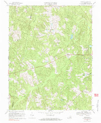
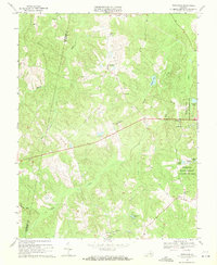
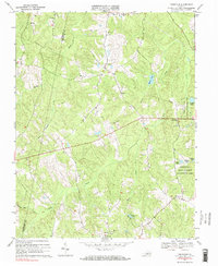
Trenholm and the surrounding rural communities of Powhatan and Cumberland Counties appear here in a landscape defined by an intricate network of narrow creek valleys. Small settlements like Hatchers, Belona, and Ballsville are connected by a spiderweb of secondary roads that cross Muddy Creek, Deep Creek, and Maple Creek. The presence of numerous country churches, such as Little Zion Ch and Mt Zion Ch, along with clustered family cemeteries marked simply as Cem, indicates a deeply rooted local history and a pattern of small-scale agriculture. To the east, the Powhatan State Wildlife Management Area encompasses a large tract of woodland, where specialized fishing ponds like Sunfish Pond and Bullhead Pond are located. This survey reflects the mid-century character of Piedmont Virginia before more modern suburban expansion altered the traditional rural corridors.
Find a feature on this map
22 named features on this map. Tap any name to fly to it.
Don’t see what you’re looking for? This feature index may not catch every label — zoom into the map to look around manually.
Map Details
Editions of this 1969 Trenholm Map
3 editions found
Other maps of this area

1890 · Goochland
USGS Topo · 1:125,000

1891 · Palmyra
USGS Topo · 1:125,000

1891 · Farmville
USGS Topo · 1:125,000

1892 · Goochland
USGS Topo · 1:125,000

1893 · Farmville
USGS Topo · 1:125,000

1895 · Palmyra
USGS Topo · 1:125,000

1897 · Amelia
USGS Topo · 1:125,000

1897 · Palmyra
USGS Topo · 1:125,000

1943 · Goochland
USGS Topo · 1:31,680

1943 · Powhatan
USGS Topo · 1:31,680