1969 Map of Trenholm
USGS Topo · Published 1984About this map
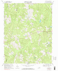
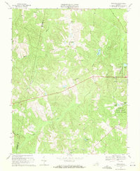
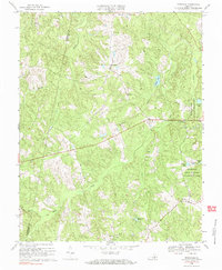
Trenholm and the surrounding central Virginia landscape are defined by a complex network of tributaries feeding into the James River basin, dominated by the winding paths of Muddy Creek and Deep Creek. This 1960s survey, updated in the late 1970s, captures a rural Piedmont community anchored by small crossroads settlements like Smiths Crossroads and Ballsville. The map reveals a high concentration of local religious centers, including Little Zion Ch and Muddy Creek Ch, which served as the social fabric for scattered farmsteads. To the east, the Powhatan State Wildlife Management Area provides a substantial buffer of undeveloped land, punctuated by man-made water features such as Powhatan Lakes, Bullhead Pond, and Bass Pond. The topography is marked by modest rises like Davis Hill, while the Cumberland Co Powhatan Co line bisects the western reaches of the quadrangle.
Find a feature on this map
29 named features on this map. Tap any name to fly to it.
Don’t see what you’re looking for? This feature index may not catch every label — zoom into the map to look around manually.
Map Details
Editions of this 1969 Trenholm Map
3 editions found
Other maps of this area

1890 · Goochland
USGS Topo · 1:125,000

1891 · Palmyra
USGS Topo · 1:125,000

1891 · Farmville
USGS Topo · 1:125,000

1892 · Goochland
USGS Topo · 1:125,000

1893 · Farmville
USGS Topo · 1:125,000

1895 · Palmyra
USGS Topo · 1:125,000

1897 · Amelia
USGS Topo · 1:125,000

1897 · Palmyra
USGS Topo · 1:125,000

1943 · Goochland
USGS Topo · 1:31,680

1943 · Powhatan
USGS Topo · 1:31,680