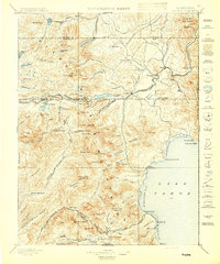
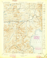
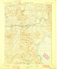
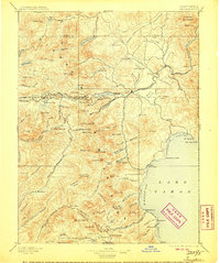
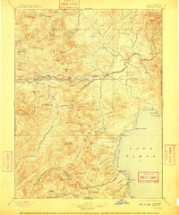
1895 Map of Truckee
USGS Topo · Published 1895About this map
The Southern Pacific RR carves through the high Sierra Nevada on this 1889 survey, tracing the critical passage through Donner Pass. The town of Truckee serves as the central hub for the region's early mountain economy, while industrial activity is evidenced by several Sawmill sites scattered through the timbered drainages of Prosser Creek and Martis Creek. Along the rail line, vital waypoints like Soda Springs Station and Boca mark the transition from the rugged peaks to the high valleys. To the south, the northwestern shore of Lake Tahoe reveals early shoreline settlements such as McKinney and Bellevue. Further into the backcountry, remote mineral and resort locations like Rubicon Springs and Wentworth Springs suggest the burgeoning interest in the Sierra's waters, while the expansive waters of Donner Lake and Independence Lake dominate the high-altitude landscape.
Find a feature on this map
140 named features on this map. Tap any name to fly to it.
Don’t see what you’re looking for? This feature index may not catch every label — zoom into the map to look around manually.
Map Details
Editions of this 1895 Truckee Map
9 editions found

Other maps of this area

1889 · Pyramid Peak
USGS Topo · 1:125,000

1889 · Markleeville
USGS Topo · 1:125,000

1890 · Sierraville
USGS Topo · 1:125,000

1891 · Downieville
USGS Topo · 1:125,000

1891 · Carson
USGS Topo · 1:125,000

1891 · Markleeville
USGS Topo · 1:125,000

1891 · Colfax
USGS Topo · 1:125,000

1891 · Truckee
USGS Topo · 1:125,000

1891 · Reno
USGS Topo · 1:125,000

1891 · Placerville
USGS Topo · 1:125,000