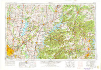
1958 Map of Tulsa
USGS Topo · Published 1975About this map
Bartlesville and the metropolitan expansion of Tulsa anchor the western edge of this mid-century survey, which details the complex hydraulic and transit networks of the Four State area. The landscape is defined by massive reservoirs like Oologah Lake, Lake The Cherokees, and Lake Hudson, which reconfigured the drainage of the Neosho River and Verdigris River systems. Rapid postwar transportation is evident in the Will Rogers State Parkway, cutting northeast through Vinita toward the lead and zinc mining districts near Miami and Commerce.
Find a feature on this map
131 named features on this map. Tap any name to fly to it.
Don’t see what you’re looking for? This feature index may not catch every label — zoom into the map to look around manually.
Map Details
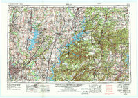
Editions of this 1958 Tulsa Map
3 editions found

Other maps of this area

1885 · Sedan
USGS Topo · 1:125,000

1886 · Joplin
USGS Topo · 1:125,000

1886 · Greenfield
USGS Topo · 1:125,000

1886 · Independence
USGS Topo · 1:125,000

1886 · Carthage
USGS Topo · 1:125,000

1886 · Parsons
USGS Topo · 1:125,000

1888 · Greenfield
USGS Topo · 1:125,000

1889 · Sedan
USGS Topo · 1:125,000

1893 · Parsons
USGS Topo · 1:125,000

1894 · Independence
USGS Topo · 1:125,000