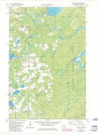
1981 Map of Turpela Lake
USGS Topo · Published 1985About this map
St Louis River and the Partridge River define the hydrography of this Northwoods landscape, where water and forestry dominate the local geography. Much of the eastern and southern portions of the map lie within the Superior National Forest, characterized by numerous glacial lakes and wetlands. Distinctive family-named water bodies such as Hautala Lake, Kumpula Lake, and Turpela Lake suggest the heritage of the area's early settlers and landowners. The presence of several Gravel Pits and a Sandpit indicates a local economy supported by mineral extraction, while the Hoyt Lakes Corporate Boundary encroaches into the northern territory. Recreational utility is noted through features like the Norway Point Picnic Area and a Heliport, reflecting the intersection of public land management and industrial activity in the Iron Range region.
Find a feature on this map
23 named features on this map. Tap any name to fly to it.
Don’t see what you’re looking for? This feature index may not catch every label — zoom into the map to look around manually.
Map Details
Editions of this 1981 Turpela Lake Map
2 editions found
Other maps of this area

1949 · Aurora
USGS Topo · 1:24,000

1949 · Allen
USGS Topo · 1:24,000

1950 · Allen
USGS Topo · 1:24,000

1950 · Aurora
USGS Topo · 1:24,000

1950 · Biwabik
USGS Topo · 1:24,000

1951 · Biwabik
USGS Topo · 1:24,000

1951 · Palo
USGS Topo · 1:24,000

1951 · Makinen
USGS Topo · 1:24,000

1954 · Hibbing
USGS Topo · 1:250,000

1957 · Hibbing
USGS Topo · 1:250,000