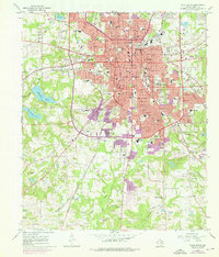
1966 Map of Tyler South
USGS Topo · Published 1976About this map
The city of Tyler undergoes significant southward expansion in the mid-1960s, a transformation tracked through purple-tinted revisions added to the original survey. Education and community infrastructure anchor this growth, with the campus of Tyler Jr College and the grounds of Butler College serving as major landmarks. The landscape transitions from the dense urban core near City Hall and the Courthouse to suburban residential areas and recreational spaces like the Caldwell Zoo and Willow Brook Country Club.
Find a feature on this map
62 named features on this map. Tap any name to fly to it.
Don’t see what you’re looking for? This feature index may not catch every label — zoom into the map to look around manually.
Map Details
Editions of this 1966 Tyler South Map
Other maps of this area

1937 · Troupe
USGS Topo · 1:48,000

1938 · Winona
USGS Topo · 1:48,000

1943 · Troup
USGS Topo · 1:62,500

1943 · Winona
USGS Topo · 1:62,500

1946 · Bullard
USGS Topo · 1:62,500

1948 · Bullard
USGS Topo · 1:62,500

1948 · Tyler
USGS Topo · 1:62,500

1949 · Tyler
USGS Topo · 1:62,500

1956 · Tyler
USGS Topo · 1:250,000

1966 · Chandler
USGS Topo · 1:24,000