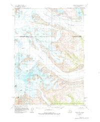
1958 Map of Tyonek B-6
USGS Topo · Published 1975About this map
Mount Spurr dominates this 1950s survey, a period when the United States Geological Survey and the Bureau of Land Management were documenting the shifting ice and volcanic activity of the southern Alaska Range. The landscape is defined by massive ice flows, including the Triumvirate Glacier, Capps Glacier, and Dogshead Glacier, each marked by extensive systems of crevasses. A significant geological insight is found near the southwestern corner, where Crater Peak is identified alongside deposits of Volcanic Ash, signaling the active nature of the terrain. The border between the Matanuska-Susitna Borough and the Kenai Peninsula Borough bisects these glacial fields. To the northeast, the presence of Strandline Lake highlights the intersection of glacial melt and stationary water bodies in this uninhabited, high-elevation environment.
Find a feature on this map
9 named features on this map. Tap any name to fly to it.
Don’t see what you’re looking for? This feature index may not catch every label — zoom into the map to look around manually.
Map Details
Editions of this 1958 Tyonek B-6 Map
2 editions found
Other maps of this area

1949 · Tyonek
USGS Topo · 1:250,000

1951 · Tyonek
USGS Topo · 1:250,000

1954 · Tyonek C-5
USGS Topo · 1:63,360

1958 · Tyonek A-6
USGS Topo · 1:63,360

1958 · Tyonek A-5
USGS Topo · 1:63,360

1958 · Tyonek C-6
USGS Topo · 1:63,360

1958 · Tyonek B-5
USGS Topo · 1:63,360

1958 · Tyonek B-6
USGS Topo · 1:63,360

1958 · Tyonek
USGS Topo · 1:250,000
1958 · Tyonek B-7
USGS Topo · 1:63,360