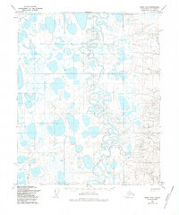
1955 Map of Umiat D-2
USGS Topo · Published 1986About this map
The Itkillik River winds through this expanse of the North Slope, forming a complex network of tight oxbows and abandoned channels across a landscape dominated by thaw lakes and saturated wetlands. Photogrammetric methods from 1955 aerial photography reveal a wilderness where drainage patterns are constantly shifting, leaving behind a series of elongated pools and marshes. In the southwestern portion of the sheet, the Winter Road provides a seasonal transit route through the tundra, likely established to support early geological exploration or local movement when the ground is frozen. This remote corridor serves as a rare human imprint on an otherwise water-logged terrain, marking the intersection of resource interest and the challenging arctic environment during the mid-century era.
Find a feature on this map
2 named features on this map. Tap any name to fly to it.
Don’t see what you’re looking for? This feature index may not catch every label — zoom into the map to look around manually.
Map Details
Editions of this 1955 Umiat D-2 Map
3 editions found
Other maps of this area

1951 · Harrison Bay
USGS Topo · 1:250,000

1952 · Umiat
USGS Topo · 1:250,000

1955 · Harrison Bay
USGS Topo · 1:250,000

1955 · Umiat D-2
USGS Topo · 1:63,360

1955 · Harrison Bay A-2
USGS Topo · 1:63,360

1955 · Harrison Bay A-3
USGS Topo · 1:63,360
1955 · Harrison Bay A-1
USGS Topo · 1:63,360

1955 · Umiat D-3
USGS Topo · 1:63,360
1955 · Umiat D-1
USGS Topo · 1:63,360

1955 · Umiat C-3
USGS Topo · 1:63,360