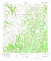
1952 Map of Unalakleet B-4
USGS Topo · Published 1963About this map
The Anvik River dominates the eastern drainage of this interior Alaskan landscape, characterized by complex river systems and unnamed peaks. Recorded by the Army Map Service during the early 1950s, the terrain reveals the natural watercourses that defined regional travel before modern infrastructure. To the west, the South River cuts through the high ground, while Otter Creek meanders through the southern reaches. This era of mapping relied heavily on 1951 aerial photography, capturing the raw geography of the Unalakleet region at a time when no roads or trails were yet established across these particular ridges and valleys.
Find a feature on this map
3 named features on this map. Tap any name to fly to it.
Don’t see what you’re looking for? This feature index may not catch every label — zoom into the map to look around manually.
Map Details
Editions of this 1952 Unalakleet B-4 Map
3 editions found
Other maps of this area

1951 · Unalakleet
USGS Topo · 1:250,000

1952 · Unalakleet A-4
USGS Topo · 1:63,360

1952 · Unalakleet A-3
USGS Topo · 1:63,360

1952 · Unalakleet A-5
USGS Topo · 1:63,360

1952 · Unalakleet B-4
USGS Topo · 1:63,360

1952 · Unalakleet C-3
USGS Topo · 1:63,360

1952 · Unalakleet C-4
USGS Topo · 1:63,360

1952 · Unalakleet B-3
USGS Topo · 1:63,360

1952 · Unalakleet B-5
USGS Topo · 1:63,360
1952 · Unalakleet C-5
USGS Topo · 1:63,360