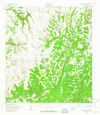
1952 Map of Unalakleet B-4
USGS Topo · Published 1963About this map
Anvik River dominates the eastern drainage of this interior Alaskan landscape, winding through a complex system of ridges and valleys as documented in the early 1950s. The terrain is defined by its watercourses, with the South River and Otter Creek carving distinct paths through the hills. This 1:63,360 scale topographic study, based on 1951 aerial photography, illustrates a completely unpopulated wilderness area without roads or established trails at the time of the survey. The intricate contour lines reveal a rugged, high-elevation plateau where the transition from river bottoms to upland summits is sharp and immediate. For researchers of Alaskan geography, the map provides a precise record of the natural hydrology and elevation before later 20th-century shifts in mapping technology and landscape management.
Find a feature on this map
3 named features on this map. Tap any name to fly to it.
Don’t see what you’re looking for? This feature index may not catch every label — zoom into the map to look around manually.
Map Details
Editions of this 1952 Unalakleet B-4 Map
3 editions found
Other maps of this area

1951 · Unalakleet
USGS Topo · 1:250,000

1952 · Unalakleet A-4
USGS Topo · 1:63,360

1952 · Unalakleet A-3
USGS Topo · 1:63,360

1952 · Unalakleet A-5
USGS Topo · 1:63,360

1952 · Unalakleet B-4
USGS Topo · 1:63,360

1952 · Unalakleet C-3
USGS Topo · 1:63,360

1952 · Unalakleet C-4
USGS Topo · 1:63,360

1952 · Unalakleet B-3
USGS Topo · 1:63,360

1952 · Unalakleet B-5
USGS Topo · 1:63,360
1952 · Unalakleet C-5
USGS Topo · 1:63,360