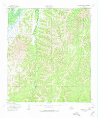
1952 Map of Unalakleet D-2
USGS Topo · Published 1974About this map
The Unalakleet River winds through this interior landscape, joined by the prominent Old Woman River as it flows toward the Norton Sound coast. Mapped by the Army Map Service based on 1950s aerial photography, the sheet records the traditional overland routes through the Unalakleet hills, including a section of the Winter Trail and the historic Kaltas Portage. These pathways represent the primary connections between coastal settlements and the Yukon River drainage during the mid-20th century. The terrain is defined by its watercourses, from larger systems like Bear Creek to smaller tributaries like Stove Creek, which served as critical navigation landmarks for travelers and hunters before the advent of modern air travel in the region.
Find a feature on this map
6 named features on this map. Tap any name to fly to it.
Don’t see what you’re looking for? This feature index may not catch every label — zoom into the map to look around manually.
Map Details
Editions of this 1952 Unalakleet D-2 Map
3 editions found
Other maps of this area

1948 · Norton Bay
USGS Topo · 1:250,000

1950 · Unalakleet D-3
USGS Topo · 1:63,360

1950 · Norton Bay A-3
USGS Topo · 1:63,360

1951 · Unalakleet
USGS Topo · 1:250,000

1951 · Norton Bay
USGS Topo · 1:250,000

1952 · Unalakleet C-2
USGS Topo · 1:63,360

1952 · Unalakleet D-2
USGS Topo · 1:63,360

1952 · Unalakleet C-3
USGS Topo · 1:63,360

1952 · Unalakleet C-1
USGS Topo · 1:63,360

1952 · Unalakleet D-1
USGS Topo · 1:63,360