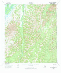
1952 Map of Unalakleet D-2
USGS Topo · Published 1984About this map
The Old Woman River meanders through this portion of the Alaska interior, joining the larger Unalakleet River valley in the northwest corner of the map. This early 1950s terrain is defined by its transit routes, most notably the Kaltac Portage and a designated Winter Trail, which represent critical overland paths used before modern infrastructure reached this part of the Nome region. These trails follow natural corridors through the hills, connecting the river systems and providing passage for seasonal travel. Tributaries like Bear Creek and Stove Creek drain the surrounding elevations, illustrating a landscape where movement was dictated by the seasonal flow of water and the orientation of the valley floors.
Find a feature on this map
6 named features on this map. Tap any name to fly to it.
Don’t see what you’re looking for? This feature index may not catch every label — zoom into the map to look around manually.
Map Details
Editions of this 1952 Unalakleet D-2 Map
3 editions found
Other maps of this area

1948 · Norton Bay
USGS Topo · 1:250,000

1950 · Unalakleet D-3
USGS Topo · 1:63,360

1950 · Norton Bay A-3
USGS Topo · 1:63,360

1951 · Unalakleet
USGS Topo · 1:250,000

1951 · Norton Bay
USGS Topo · 1:250,000

1952 · Unalakleet C-2
USGS Topo · 1:63,360

1952 · Unalakleet D-2
USGS Topo · 1:63,360

1952 · Unalakleet C-3
USGS Topo · 1:63,360

1952 · Unalakleet C-1
USGS Topo · 1:63,360

1952 · Unalakleet D-1
USGS Topo · 1:63,360