
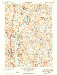
1952 Map of Uncasville
USGS Topo · Published 1952This historical map portrays the area of Uncasville in 1952, primarily covering New London. Featuring a scale of 1:31680, this map provides a highly detailed snapshot of the terrain, roads, buildings, counties, and historical landmarks in the Uncasville region at the time. Published in 1952, it is one of 2 known editions of this map due to revisions or reprints.
Find a feature on this map
105 named features on this map. Tap any name to fly to it.
Don’t see what you’re looking for? This feature index may not catch every label — zoom into the map to look around manually.
Map Details
Editions of this 1952 Uncasville Map
2 editions found
Historical Maps of Norwich Through Time
26 maps found

1889 Stonington
New London County, CT

1893 Stonington
New London County, CT

1921 Stonington
New London County, CT

1935 Montville
New London County, CT

1939 Montville
New London County, CT

1941 Lyme
New London County, CT

1941 Uncasville
New London County, CT

1942 Block Island
New London County, CT

1943 Fitchville
New London County, CT

1943 Putnam
New London County, CT

1943 Voluntown
New London County, CT

1945 Colchester
New London County, CT

1951 Lyme
New London County, CT

1952 Hamburg
New London County, CT
1952 Uncasville
New London County, CT

1953 Colchester
New London County, CT

1953 Fitchville
New London County, CT

1953 Voluntown
New London County, CT

1958 Montville
New London County, CT

1958 Old Lyme
New London County, CT

1958 Uncasville
New London County, CT

1961 Hamburg
New London County, CT

1983 Fitchville
New London County, CT

1983 Montville
New London County, CT

1984 Uncasville
New London County, CT

2001 Voluntown
New London County, CT