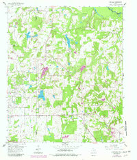
1959 Map of Van Lake
USGS Topo · Published 1982About this map
The Van Oil Field dominates the western landscape of this Smith County survey, where a network of pipelines and industrial sites like the WT Filtration Plant intersect with a rural agricultural community. This area, updated with 1978 aerial data, captures the transition between intensive resource extraction and established East Texas settlements. Small communities and spiritual centers such as Jamestown, Garden Valley, and Union Chapel provide local orientation amidst a complex drainage system defined by Village Creek and the Sabine River along the northern border.
Find a feature on this map
29 named features on this map. Tap any name to fly to it.
Don’t see what you’re looking for? This feature index may not catch every label — zoom into the map to look around manually.
Map Details
Editions of this 1959 Van Lake Map
4 editions found
Other maps of this area

1948 · Tyler
USGS Topo · 1:62,500

1948 · Brownsboro
USGS Topo · 1:62,500

1949 · Tyler
USGS Topo · 1:62,500

1949 · Brownsboro
USGS Topo · 1:62,500

1956 · Tyler
USGS Topo · 1:250,000

1959 · Golden
USGS Topo · 1:24,000

1959 · Grand Saline
USGS Topo · 1:24,000

1959 · Van
USGS Topo · 1:24,000

1959 · Van Lake
USGS Topo · 1:24,000

1959 · Grand Saline
USGS Topo · 1:62,500