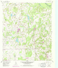
1959 Map of Van Lake
USGS Topo · Published 1986About this map
The Van Oil Field dominates the western portion of this 1959 survey, marking the industrial character of the Smith and Van Zandt county line during the late 1950s. This energy infrastructure, including a Water Filtration Plant and a Disposal Well (Salt) near Van Lake, contrasts with the traditional rural settlements found to the east. The map preserves the locations of early local congregations and burial grounds, such as Providence Ch, Duck Creek Ch, and the Bowman Cem. Natural drainage patterns are defined by the Sabine River at the northern edge, fed by a network of waterways including Village Creek, Rock Creek, and Rattlesnake Creek. A Historical Marker near Village Creek further emphasizes the deep-rooted local history found within this East Texas landscape.
Find a feature on this map
30 named features on this map. Tap any name to fly to it.
Don’t see what you’re looking for? This feature index may not catch every label — zoom into the map to look around manually.
Map Details
Editions of this 1959 Van Lake Map
4 editions found
Other maps of this area

1948 · Tyler
USGS Topo · 1:62,500

1948 · Brownsboro
USGS Topo · 1:62,500

1949 · Tyler
USGS Topo · 1:62,500

1949 · Brownsboro
USGS Topo · 1:62,500

1956 · Tyler
USGS Topo · 1:250,000

1959 · Golden
USGS Topo · 1:24,000

1959 · Grand Saline
USGS Topo · 1:24,000

1959 · Van
USGS Topo · 1:24,000

1959 · Van Lake
USGS Topo · 1:24,000

1959 · Grand Saline
USGS Topo · 1:62,500