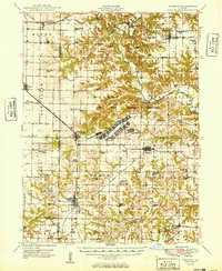
1949 Map of Vermont
USGS Topo · Published 1949About this map
Camp Ellis Military Reservation dominates the central landscape of this mid-century survey, its sprawling footprint including the Camp Ellis Landing Strip and localized infrastructure like a Sewage Disposal plant. The area is defined by the winding course of the Spoon River, which is spanned by the Bernadotte Bridge and Elrod Bridge. Settlement patterns follow the established corridors of the Chicago Burlington and Quincy and the Toledo Peoria and Western railroads, connecting rural hubs like Table Grove, Ipava, and Vermont.
Find a feature on this map
87 named features on this map. Tap any name to fly to it.
Don’t see what you’re looking for? This feature index may not catch every label — zoom into the map to look around manually.
Map Details
Editions of this 1949 Vermont Map
2 editions found
Other maps of this area

1912 · Canton
USGS Topo · 1:62,500

1912 · Macomb
USGS Topo · 1:62,500

1914 · Macomb
USGS Topo · 1:62,500

1915 · Avon
USGS Topo · 1:62,500

1916 · Good Hope
USGS Topo · 1:62,500

1918 · Vermont
USGS Topo · 1:62,500

1918 · Good Hope
USGS Topo · 1:62,500

1921 · Vermont
USGS Topo · 1:62,500

1923 · Rushville
USGS Topo · 1:62,500

1925 · Havana
USGS Topo · 1:62,500