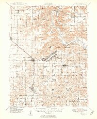
1949 Map of Vermont
USGS Topo · Published 1949About this map
The Camp Ellis Military Reservation dominates the center of this Fulton County landscape, showcasing the sprawling infrastructure of this World War II-era training camp and prisoner-of-war facility. Detailed surveying reveals the camp's extensive rail spurs, barracks layouts, and the Camp Ellis Landing Strip, situated just west of the Spoon River. This military presence is superimposed over a rural network of traditional Illinois townships like Farmer and Bernadotte, where the Bernadotte Bridge spans the winding river.
Find a feature on this map
94 named features on this map. Tap any name to fly to it.
Don’t see what you’re looking for? This feature index may not catch every label — zoom into the map to look around manually.
Map Details
Editions of this 1949 Vermont Map
2 editions found
Other maps of this area

1912 · Canton
USGS Topo · 1:62,500

1912 · Macomb
USGS Topo · 1:62,500

1914 · Macomb
USGS Topo · 1:62,500

1915 · Avon
USGS Topo · 1:62,500

1916 · Good Hope
USGS Topo · 1:62,500

1918 · Vermont
USGS Topo · 1:62,500

1918 · Good Hope
USGS Topo · 1:62,500

1921 · Vermont
USGS Topo · 1:62,500

1923 · Rushville
USGS Topo · 1:62,500

1925 · Havana
USGS Topo · 1:62,500