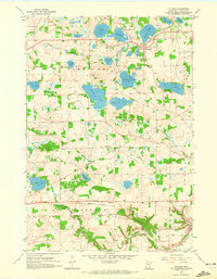
1958 Map of Victoria
USGS Topo · Published 1972About this map
Victoria serves as a central hub in this Carver County landscape, situated at the junction of several freshwater bodies and the Chicago and North Western railroad. The map reveals a post-war rural environment where agricultural life is deeply tied to the numerous lakes, such as Lake Bavaria, Wassermann Lake, and Auburn Lake. Small, established communities like Augusta and Dahlgren are clearly delineated, connected by the paths of the Chicago Milwaukee St Paul and Pacific line.
Find a feature on this map
38 named features on this map. Tap any name to fly to it.
Don’t see what you’re looking for? This feature index may not catch every label — zoom into the map to look around manually.
Map Details
Editions of this 1958 Victoria Map
4 editions found
Other maps of this area

1905 · Minnetonka
USGS Topo · 1:62,500

1907 · Minnetonka
USGS Topo · 1:62,500

1953 · Saint Paul
USGS Topo · 1:250,000

1957 · Belle Plaine
USGS Topo · 1:62,500

1957 · Waconia
USGS Topo · 1:62,500

1957 · New Prague
USGS Topo · 1:62,500

1958 · Victoria
USGS Topo · 1:24,000

1958 · Mound
USGS Topo · 1:24,000

1958 · Lake Minnetonka
USGS Topo · 1:62,500
1958 · Shakopee
USGS Topo · 1:24,000