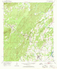
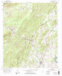
1951 Map of Vincent
USGS Topo · Published 1969About this map
The Central of Georgia and Atlantic Coast Line railroads converge in this mid-century view of Shelby County, Alabama, anchoring the local economy around the town of Vincent. The landscape is defined by the prominent Black Ridge and Quarry Mountain, where numerous small community landmarks speak to the rural social fabric of the era. The mapping documents several denominational congregations and family burial sites, including Beulah Ch and Elliott Cem. Along the eastern edge, the Coosa River marks the boundary near Coosa Valley Ch, while interior settlements like Sterrett and Calcis are situated along the rail lines and creek drainage systems. This 1951 field-checked survey preserves the layout of a transition period where the historic rail network still dictates the settlement pattern between Higdon Point and the banks of Kelly Creek.
Find a feature on this map
43 named features on this map. Tap any name to fly to it.
Don’t see what you’re looking for? This feature index may not catch every label — zoom into the map to look around manually.
Map Details
Editions of this 1951 Vincent Map
6 editions found

Other maps of this area

1889 · Springville
USGS Topo · 1:125,000

1889 · Birmingham
USGS Topo · 1:125,000

1890 · Bessemer
USGS Topo · 1:125,000

1890 · Talladega
USGS Topo · 1:125,000

1892 · Birmingham
USGS Topo · 1:125,000

1892 · Springville
USGS Topo · 1:125,000

1892 · Talladega
USGS Topo · 1:125,000

1892 · Bessemer
USGS Topo · 1:125,000

1895 · Birmingham
USGS Topo · 1:125,000

1905 · Leeds
USGS Topo · 1:62,500