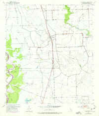
1952 Map of Wadsworth
USGS Topo · Published 1976About this map
Wadsworth serves as the central hub of this coastal Texas landscape, where the Atchison Topeka and Santa Fe railroad cuts a straight line through the low-lying prairie. The terrain is defined by a complex hydraulic system of natural creeks and engineered protection, including an extensive network of levee structures bordering Big Boggy Creek and the Colorado River. To the west, the river winds past riverine features like Dick Island and Selkirk Island, while the eastern portion of the map shows the transition toward the coastal marshes near Wadsworth Slough. Historical infrastructure is evident in the Old Railroad Grade near Gulf Hill, offering a clear look at the region's early transportation and drainage patterns. Local landmarks such as St Francis Ch and smaller settlements like Rymers provide essential points of reference for genealogists tracing family locations in Matagorda County during the mid-20th century.
Find a feature on this map
18 named features on this map. Tap any name to fly to it.
Don’t see what you’re looking for? This feature index may not catch every label — zoom into the map to look around manually.
Map Details
Editions of this 1952 Wadsworth Map
3 editions found
Other maps of this area

1951 · Bay City
USGS Topo · 1:250,000

1952 · Lake Austin
USGS Topo · 1:24,000

1952 · Matagorda
USGS Topo · 1:24,000

1952 · Blessing SE
USGS Topo · 1:24,000

1952 · Dressing Point
USGS Topo · 1:24,000

1952 · Bay City
USGS Topo · 1:24,000

1952 · Markham
USGS Topo · 1:24,000

1952 · Bay City NE
USGS Topo · 1:24,000

1952 · Palacios NE
USGS Topo · 1:24,000

1952 · Wadsworth
USGS Topo · 1:24,000