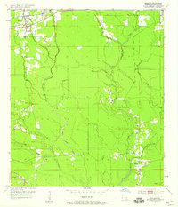
1953 Map of Walker
USGS Topo · Published 1959About this map
Walker and Corbin serve as the primary rail-oriented hubs of this Livingston Parish landscape, situated along the Illinois Central railroad corridor. The area is defined by an intricate network of waterways, including Middle Colyell Creek, West Colyell Creek, and the wandering Hornsby Creek. This 1950s survey captures a rural South Louisiana community structured around its creeks and bayous, where navigation and drainage patterns influenced the placement of early infrastructure. Landmarks such as the Walker Lookout Tower and institutional anchors like the Frost Sch and Satsuma Ch provide clear geographic reference points for the era. The mapping of cemeteries like Palmetto Cem and Petes Rest Cem offers specific value for genealogists tracing family histories in the deep woods and bottomlands of the Florida Parishes during a period of steady post-war growth.
Find a feature on this map
20 named features on this map. Tap any name to fly to it.
Don’t see what you’re looking for? This feature index may not catch every label — zoom into the map to look around manually.
Map Details
Editions of this 1953 Walker Map
2 editions found
Other maps of this area

1934 · Denham Springs
USGS Topo · 1:62,500

1934 · Springfield
USGS Topo · 1:62,500

1939 · Springfield
USGS Topo · 1:62,500

1939 · Denham Springs
USGS Topo · 1:62,500

1942 · Watson
USGS Topo · 1:31,680

1942 · Satsuma
USGS Topo · 1:31,680

1950 · Doyle
USGS Topo · 1:31,680

1953 · Walker
USGS Topo · 1:24,000
1953 · Prairieville
USGS Topo · 1:24,000
1953 · French Settlement
USGS Topo · 1:24,000