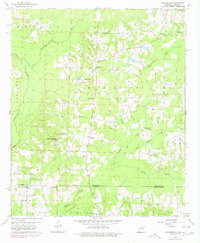
1960 Map of Walkerville
USGS Topo · Published 1978About this map
Walkerville and Horsehead anchor this landscape along the state line where Columbia County and Webster Parish meet. This 1960s-era geography reveals a rural economy shaped by extractive industries and small-scale religious centers. Multiple oil-producing zones, including the Horsehead Oil Field and North Shongaloo Oil Field, sit alongside scattered gravel pits, indicating the region's industrial footprint during the mid-century.
Find a feature on this map
28 named features on this map. Tap any name to fly to it.
Don’t see what you’re looking for? This feature index may not catch every label — zoom into the map to look around manually.
Map Details
Editions of this 1960 Walkerville Map
3 editions found

Other maps of this area

1922 · Sarepta
USGS Topo · 1:62,500

1924 · Sarepta
USGS Topo · 1:62,500

1952 · Homer
USGS Topo · 1:62,500

1953 · El Dorado
USGS Topo · 1:250,000

1955 · Shreveport
USGS Topo · 1:250,000

1956 · Shreveport
USGS Topo · 1:250,000

1956 · Sarepta
USGS Topo · 1:62,500

1957 · El Dorado
USGS Topo · 1:250,000

1958 · El Dorado
USGS Topo · 1:250,000

1960 · El Dorado
USGS Topo · 1:250,000