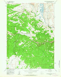
1956 Map of Warm Spring Mountain
USGS Topo · Published 1963About this map
Shoshone National Forest dominates this mid-century landscape, characterized by high-elevation summits and a network of creeks and irrigation ditches. The topography is anchored by Warm Spring Mountain and Geyser Park, while human industry is evidenced by the Smith Sawmill and several ranching outposts like Rocker A Ranch and Sheer Ranch. The map captures a moment of transition for local settlements, noting Du Noir (Aban'd) as a vanished location with remaining ruins. Significant water features including the North Fork Wind River and Lake of the Woods define the drainage patterns, while an Abandoned Ditch and a Lookout Tower reflect the evolving management of these western timberlands and watersheds during the 1950s.
Find a feature on this map
31 named features on this map. Tap any name to fly to it.
Don’t see what you’re looking for? This feature index may not catch every label — zoom into the map to look around manually.
Map Details
Editions of this 1956 Warm Spring Mountain Map
5 editions found
Other maps of this area

1905 · Younts Peak
USGS Topo · 1:125,000

1907 · Younts Peak
USGS Topo · 1:125,000

1909 · Fremont Peak
USGS Topo · 1:125,000

1955 · Thermopolis
USGS Topo · 1:250,000

1956 · Dubois
USGS Topo · 1:24,000

1956 · Esmond Park
USGS Topo · 1:24,000

1956 · Ramshorn Peak
USGS Topo · 1:24,000

1956 · Warm Spring Mountain
USGS Topo · 1:24,000

1956 · Fish Lake
USGS Topo · 1:24,000

1956 · Kisinger Lakes
USGS Topo · 1:24,000