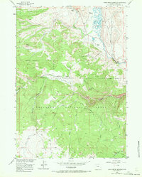
1956 Map of Warm Spring Mountain
USGS Topo · Published 1972About this map
Shoshone National Forest lands dominate this mid-century survey, revealing a landscape defined by ranching outposts and high-altitude trails. The convergence of the North Fork Wind River and the Du Noir River creates a corridor where established properties like Rocker A Ranch and Sheer Ranch were situated during the 1950s. The presence of irrigation infrastructure, such as the Ditch system near Johnson Camp, highlights the efforts to manage water in this high country.
Find a feature on this map
32 named features on this map. Tap any name to fly to it.
Don’t see what you’re looking for? This feature index may not catch every label — zoom into the map to look around manually.
Map Details
Editions of this 1956 Warm Spring Mountain Map
5 editions found
Other maps of this area

1905 · Younts Peak
USGS Topo · 1:125,000

1907 · Younts Peak
USGS Topo · 1:125,000

1909 · Fremont Peak
USGS Topo · 1:125,000

1955 · Thermopolis
USGS Topo · 1:250,000

1956 · Dubois
USGS Topo · 1:24,000

1956 · Esmond Park
USGS Topo · 1:24,000

1956 · Ramshorn Peak
USGS Topo · 1:24,000

1956 · Warm Spring Mountain
USGS Topo · 1:24,000

1956 · Fish Lake
USGS Topo · 1:24,000

1956 · Kisinger Lakes
USGS Topo · 1:24,000