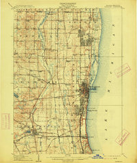
1908 Map of Waukegan
USGS Topo · Published 1914About this map
The Lake Michigan shoreline in northeastern Illinois presents a landscape transitioning from the industrial and urban centers of Waukegan and North Chicago to the planned religious community of Zion City. This 1906 survey captures the area during a period of intense railway development, featuring the Chicago and Northwestern RR, the Chicago Milwaukee and St Paul RR, and the Chicago and Milwaukee Electric RR paralleling the coast. Inland, the Des Plaines River meanders through more rural terrain, where numerous small settlement hubs like Rosecrans, Wadsworth, and Gurnee are established. To the south, Libertyville and the nearby St Marys Academy mark the region's southern growth, while the presence of Camp Logan and various Golf Links along the coast reflects the early 20th-century mix of military and recreational land use before modern suburban expansion.
Find a feature on this map
99 named features on this map. Tap any name to fly to it.
Don’t see what you’re looking for? This feature index may not catch every label — zoom into the map to look around manually.
Map Details
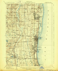
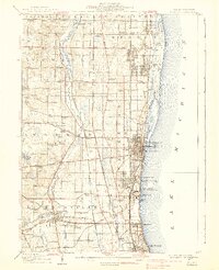
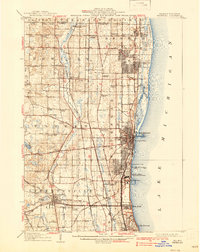
Editions of this 1908 Waukegan Map
5 editions found
Other maps of this area

1892 · Racine
USGS Topo · 1:62,500

1893 · Silver Lake
USGS Topo · 1:62,500

1899 · Evanston
USGS Topo · 1:62,500

1900 · Highwood
USGS Topo · 1:62,500

1905 · Racine
USGS Topo · 1:62,500

1906 · Silver Lake
USGS Topo · 1:62,500

1906 · Waukegan
USGS Topo · 1:62,500

1908 · Waukegan
USGS Topo · 1:62,500

1920 · Grays Lake
USGS Topo · 1:62,500

1923 · Grays Lake
USGS Topo · 1:62,500