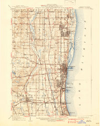
1908 Map of Waukegan
USGS Topo · Published 1939About this map
Waukegan and the expanding industrial shoreline of Lake Michigan anchor this early 20th-century landscape as the region transitioned from a collection of rural crossroads into a military and manufacturing hub. Along the coast, the U.S. Naval Training Station and Camp Logan mark the significant military presence that would define the lakefront for decades. Inland, the Des Plaines River winds through a dense network of family-named settlements like Rolls Corners, Dillys Corners, and Spaulding Corners, revealing a map where nearly every major intersection served as a local waypoint. The infrastructure is dominated by the reach of the Chicago and Northwestern and other major rail lines that fueled the growth of Zion City and Libertyville. From the White Sulphur Spr to the numerous rural schools like Waterbury School and Dady School, the map provides a comprehensive view of Lake County's social and economic geography before the era of modern suburbanization.
Find a feature on this map
102 named features on this map. Tap any name to fly to it.
Don’t see what you’re looking for? This feature index may not catch every label — zoom into the map to look around manually.
Map Details
Editions of this 1908 Waukegan Map
5 editions found
Other maps of this area

1892 · Racine
USGS Topo · 1:62,500

1893 · Silver Lake
USGS Topo · 1:62,500

1899 · Evanston
USGS Topo · 1:62,500

1900 · Highwood
USGS Topo · 1:62,500

1905 · Racine
USGS Topo · 1:62,500

1906 · Silver Lake
USGS Topo · 1:62,500

1906 · Waukegan
USGS Topo · 1:62,500

1908 · Waukegan
USGS Topo · 1:62,500

1920 · Grays Lake
USGS Topo · 1:62,500

1923 · Grays Lake
USGS Topo · 1:62,500