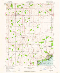
1961 Map of Waynesfield
USGS Topo · Published 1962About this map
Waynesfield serves as the primary hub in this corner of Auglaize County, characterized by a grid of agricultural section lines and small rural cemeteries. The landscape is defined by the headwaters of Muchinippi Creek and Focht Creek, which drain the surrounding farmland of Wayne and Goshen townships. To the south, the terrain transitions into the recreation-focused shores of Indian Lake, where developed points like Island View and Chippewa Island contrast with the northern agrarian layout.
Find a feature on this map
51 named features on this map. Tap any name to fly to it.
Don’t see what you’re looking for? This feature index may not catch every label — zoom into the map to look around manually.
Map Details
Editions of this 1961 Waynesfield Map
3 editions found
Other maps of this area

1906 · Lima
USGS Topo · 1:62,500

1913 · Alger
USGS Topo · 1:48,000

1913 · Bellefontaine
USGS Topo · 1:48,000

1913 · Sidney
USGS Topo · 1:62,500

1915 · Alger
USGS Topo · 1:62,500

1915 · Bellefontaine
USGS Topo · 1:62,500

1943 · Alger
USGS Topo · 1:62,500

1944 · Sidney
USGS Topo · 1:62,500

1944 · Bellefontaine
USGS Topo · 1:62,500

1950 · Marion
USGS Topo · 1:250,000