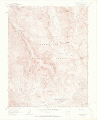
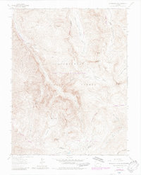
1963 Map of Wetterhorn Peak
USGS Topo · Published 1970About this map
Wetterhorn Peak and the surrounding high-altitude wilderness of the Uncompahgre National Forest dominate this 1960s study of the San Juan Mountains. The landscape is defined by its verticality, where prominent summits like Coxcomb Peak and Precipice Peak overlook deep drainages such as Wetterhorn Basin and Porphyry Basin. Evidence of early exploration and resource extraction is visible through numerous Prospects and a Mine scattered across the steep slopes. The map traces an extensive network of primitive routes, including the Green Mountain Trail, West Fork Trail, and the Mary Alice Creek Trail, which navigate through alpine features like American Flats and Bighorn Ridge. This era shows the region as a high-country frontier, where jurisdictional lines like the Hinsdale and Ouray County boundary were still being precisely defined across the Indefinite Boundary.
Find a feature on this map
43 named features on this map. Tap any name to fly to it.
Don’t see what you’re looking for? This feature index may not catch every label — zoom into the map to look around manually.
Map Details
Editions of this 1963 Wetterhorn Peak Map
7 editions found
Other maps of this area

1897 · Silverton
USGS Topo · 1:62,500

1901 · Silverton
USGS Topo · 1:62,500

1902 · Silverton
USGS Topo · 1:62,500

1902 · Ouray
USGS Topo · 1:62,500

1903 · Lake City
USGS Topo · 1:62,500

1904 · Ouray
USGS Topo · 1:62,500

1905 · Lake City
USGS Topo · 1:62,500

1905 · San Cristobal
USGS Topo · 1:125,000

1907 · San Cristobal
USGS Topo · 1:125,000

1908 · Uncompahgre
USGS Topo · 1:125,000