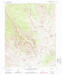
1963 Map of Wetterhorn Peak
USGS Topo · Published 1987About this map
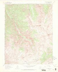
Wetterhorn Peak and the high alpine terrain of the San Juan Mountains dominate this 1963 survey, revised in the early 1980s. The landscape is defined by its dramatic verticality, stretching from the Porphyry Basin and Wetterhorn Basin up to sharp summits like Precipice Peak and Coxcomb Peak. Human presence in this area of the Uncompahgre National Forest is evidenced by a network of pack and jeep trails, such as the Cow Creek Trail (Pack) and the Henson Creek Jeep Trail, which provide access to high-altitude landmarks like American Flats. Small-scale industrial activity is noted through scattered labels for a Mine and various Prospects, particularly around Bighorn Ridge. The map also captures the headwaters of significant drainage systems, including the West Fork Cimarron River and Middle Fork Cimarron River, which carve through the Big Blue Wilderness as it straddles the Ouray Co and Hinsdale Co line.
Find a feature on this map
35 named features on this map. Tap any name to fly to it.
Don’t see what you’re looking for? This feature index may not catch every label — zoom into the map to look around manually.
Map Details
Editions of this 1963 Wetterhorn Peak Map
7 editions found
Other maps of this area

1897 · Silverton
USGS Topo · 1:62,500

1901 · Silverton
USGS Topo · 1:62,500

1902 · Silverton
USGS Topo · 1:62,500

1902 · Ouray
USGS Topo · 1:62,500

1903 · Lake City
USGS Topo · 1:62,500

1904 · Ouray
USGS Topo · 1:62,500

1905 · Lake City
USGS Topo · 1:62,500

1905 · San Cristobal
USGS Topo · 1:125,000

1907 · San Cristobal
USGS Topo · 1:125,000

1908 · Uncompahgre
USGS Topo · 1:125,000