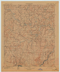
1900 Map of Wewoka
USGS Topo · Published 1913About this map
Wewoka and Holdenville stand as central hubs in this late-nineteenth-century survey of Indian Territory, a landscape defined by the political boundaries of the Seminole Nation, Creek Nation, and Choctaw Nation. The Oklahoma City and Gulf R. R. cuts through the southwestern corner, providing a modern transport link to emerging settlements like Grier and Marks Store. This era is characterized by the coexistence of established tribal centers and small trading outposts scattered across the drainages of the North Canadian River and Canadian River.
Find a feature on this map
40 named features on this map. Tap any name to fly to it.
Don’t see what you’re looking for? This feature index may not catch every label — zoom into the map to look around manually.
Map Details
Editions of this 1900 Wewoka Map
4 editions found
Other maps of this area

1896 · Seminole and Prague
USGS Topo · 1:125,000

1896 · Okmulgee
USGS Topo · 1:125,000

1896 · Coalgate
USGS Topo · 1:125,000

1898 · McAlester
USGS Topo · 1:125,000

1899 · Coalgate
USGS Topo · 1:125,000

1900 · Canadian
USGS Topo · 1:125,000

1900 · Wewoka
USGS Topo · 1:125,000

1900 · Okmulgee
USGS Topo · 1:125,000

1900 · Coalgate
USGS Topo · 1:125,000

1901 · Stonewall
USGS Topo · 1:125,000