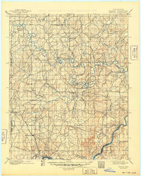
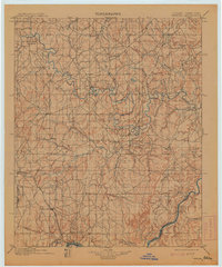
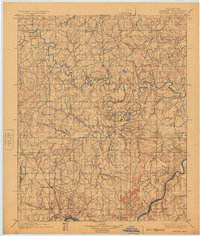
1900 Map of Wewoka
USGS Topo · Published 1949About this map
The North Canadian River and the southern Canadian River snake across this late nineteenth-century landscape of the Indian Territory, a region defined by its tribal jurisdictions and burgeoning settlements. The topography, surveyed by D.C. Harrison and his team just years before Oklahoma statehood, meticulously documents the tribal boundaries between the Seminole Nation and Creek Nation, as well as the Choctaw Nation.
Find a feature on this map
46 named features on this map. Tap any name to fly to it.
Don’t see what you’re looking for? This feature index may not catch every label — zoom into the map to look around manually.
Map Details
Editions of this 1900 Wewoka Map
4 editions found
Other maps of this area

1896 · Seminole and Prague
USGS Topo · 1:125,000

1896 · Okmulgee
USGS Topo · 1:125,000

1896 · Coalgate
USGS Topo · 1:125,000

1898 · McAlester
USGS Topo · 1:125,000

1899 · Coalgate
USGS Topo · 1:125,000

1900 · Canadian
USGS Topo · 1:125,000

1900 · Wewoka
USGS Topo · 1:125,000

1900 · Okmulgee
USGS Topo · 1:125,000

1900 · Coalgate
USGS Topo · 1:125,000

1901 · Stonewall
USGS Topo · 1:125,000