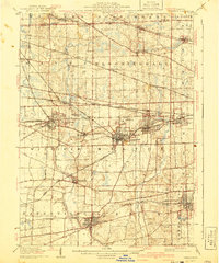
1908 Map of Wheaton
USGS Topo · Published 1941About this map
The West Branch Du Page River and the East Branch Du Page River carve through the landscape of DuPage County in this detailed record of the early 20th century. Large townships like Milton, Naperville, and Bloomingdale define the regional structure, while the city of Wheaton stands as a central hub, notably featuring the Wheaton Driving Park. The map reveals a dense network of early transportation, highlighting the importance of the Chicago and Northwestern RR and the Chicago Aurora and Elgin Electric RR in connecting satellite communities like West Chicago, Lisle, and Downers Grove. Local landmarks such as St Johns Church near Schaumberg and smaller rail stops like Eola and Gretna offer valuable insights for genealogists and local historians tracing the development of the suburban Chicago fringe during this era of rapid growth.
Find a feature on this map
60 named features on this map. Tap any name to fly to it.
Don’t see what you’re looking for? This feature index may not catch every label — zoom into the map to look around manually.
Map Details
Editions of this 1908 Wheaton Map
5 editions found

Other maps of this area

1890 · Des Plaines
USGS Topo · 1:62,500

1891 · Riverside
USGS Topo · 1:62,500

1892 · Joliet
USGS Topo · 1:62,500

1893 · Riverside
USGS Topo · 1:62,500

1894 · Des Plaines
USGS Topo · 1:62,500

1900 · Des Plaines
USGS Topo · 1:62,500

1900 · Riverside
USGS Topo · 1:62,500

1900 · Highwood
USGS Topo · 1:62,500

1901 · Des Plaines
USGS Topo · 1:62,500

1901 · Riverside
USGS Topo · 1:62,500