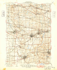
1908 Map of Wheaton
USGS Topo · Published 1949About this map
The West Branch Du Page River and East Branch Du Page River define the agricultural and suburban landscape of central DuPage County during this era of rapid transit-driven growth. Centered on the hub of Wheaton, the map illustrates a complex web of steam and electric lines, including the Chicago Great Western and the Aurora Elgin and Chicago Electric, which facilitated the expansion of commuter settlements like Glen Ellyn and Lombard. While larger towns show established street grids, the map also preserves smaller, potentially vanished locations and rail stops such as Gretna, Swift, and Meacham. Notable landmarks like St Johns Church and numerous cemeteries provide valuable points of reference for genealogists tracking family roots in townships like Bloomingdale and Milton. The transition from rural crossroads at Wayne Center to the developing town centers reflects the shifting economic character of the region just before mid-century modernization.
Find a feature on this map
74 named features on this map. Tap any name to fly to it.
Don’t see what you’re looking for? This feature index may not catch every label — zoom into the map to look around manually.
Map Details
Editions of this 1908 Wheaton Map
5 editions found

Other maps of this area

1890 · Des Plaines
USGS Topo · 1:62,500

1891 · Riverside
USGS Topo · 1:62,500

1892 · Joliet
USGS Topo · 1:62,500

1893 · Riverside
USGS Topo · 1:62,500

1894 · Des Plaines
USGS Topo · 1:62,500

1900 · Des Plaines
USGS Topo · 1:62,500

1900 · Riverside
USGS Topo · 1:62,500

1900 · Highwood
USGS Topo · 1:62,500

1901 · Des Plaines
USGS Topo · 1:62,500

1901 · Riverside
USGS Topo · 1:62,500