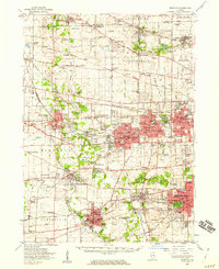
1954 Map of Wheaton
USGS Topo · Published 1960About this map
The West Branch Du Page River and East Branch Du Page River carve through this mid-century landscape of expanding residential hubs and established educational institutions. The area is defined by a high concentration of schools and seminaries, including Wheaton College, North Central College, and the sprawling Maryknoll Seminary grounds near Glen Ellyn. Outside the residential centers of Wheaton and Naperville, the map preserves the footprints of social and agricultural history, from the County Home and Zace Sanitarium to the U of Illinois Experiment Sta. The Morton Arboretum stands as a significant green space amidst the grid of roads like Army Trail Road and Butterfield Road, while the numerous gravel pits and quarries along the river branches point to the region's active material industry during this era of suburban growth.
Find a feature on this map
140 named features on this map. Tap any name to fly to it.
Don’t see what you’re looking for? This feature index may not catch every label — zoom into the map to look around manually.
Map Details
Editions of this 1954 Wheaton Map
2 editions found
Other maps of this area

1890 · Des Plaines
USGS Topo · 1:62,500

1891 · Riverside
USGS Topo · 1:62,500

1892 · Joliet
USGS Topo · 1:62,500

1893 · Riverside
USGS Topo · 1:62,500

1894 · Des Plaines
USGS Topo · 1:62,500

1900 · Des Plaines
USGS Topo · 1:62,500

1900 · Riverside
USGS Topo · 1:62,500

1900 · Highwood
USGS Topo · 1:62,500

1901 · Des Plaines
USGS Topo · 1:62,500

1901 · Riverside
USGS Topo · 1:62,500