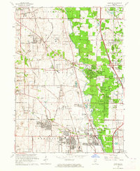
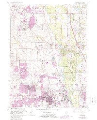
1963 Map of Wheeling
USGS Topo · Published 1964About this map
The Des Plaines River corridor defines this portion of northeastern Illinois, where the post-war suburban transition is visible alongside established estates and institutional grounds. Development radiates from hubs like Wheeling and Buffalo Grove, while the Tri-State Tollway cuts north toward Lake Forest. This era of growth is balanced by a significant concentration of preserved land and specialized facilities, including the U S Military Reservation and the sprawling Chicagoland Airport. Local history is preserved in numerous burial grounds such as St Marys Cem and Diamond Lake Cem, while educational institutions like Lake Forest Academy and Trinity Seminary reflect the area's long-standing academic character. The map also documents the localized industry of the time with several Gravel Pits scattered near the river, and early recreational sites such as Camp Dan Beard and the Chevy Chase Golf Club.
Find a feature on this map
95 named features on this map. Tap any name to fly to it.
Don’t see what you’re looking for? This feature index may not catch every label — zoom into the map to look around manually.
Map Details
Editions of this 1963 Wheeling Map
5 editions found
Other maps of this area

1900 · Highwood
USGS Topo · 1:62,500

1906 · Waukegan
USGS Topo · 1:62,500

1908 · Waukegan
USGS Topo · 1:62,500

1920 · Grays Lake
USGS Topo · 1:62,500

1923 · Grays Lake
USGS Topo · 1:62,500

1923 · Barrington
USGS Topo · 1:62,500

1927 · Arlington Heights
USGS Topo · 1:24,000

1928 · Wheeling
USGS Topo · 1:24,000

1928 · Highland Park
USGS Topo · 1:24,000

1929 · Park Ridge
USGS Topo · 1:24,000