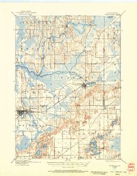
1903 Map of Whitewater
USGS Topo · Published 1959About this map
Whitewater serves as a primary hub for this early twentieth-century landscape, situated along the Chicago Milwaukee and St Paul railroad. The geography is defined by a dense network of marshes and water bodies, with the Scuppernong River and Bark River winding through the townships of Hebron and Sullivan. Small agricultural and milling centers like Heaths Mills, Rome, and Hebron appear as they did before modern expansion, while Palmyra sits at the junction of rail and river near Spring Lake. To the south, the terrain transitions into a concentrated lake district featuring Lauderdale Lakes and Whitewater Lake, surrounded by small settlements like Little Prairie and Lagrange. This 1903 revision, based on surveys by Van. H. Manning Jr. and H.L. McDonald, captures the intricate glacial topography of the Jefferson and Walworth county lines at a time when local life was closely tied to these waterways and rail spurs.
Find a feature on this map
32 named features on this map. Tap any name to fly to it.
Don’t see what you’re looking for? This feature index may not catch every label — zoom into the map to look around manually.
Map Details
Editions of this 1903 Whitewater Map
5 editions found

Other maps of this area

1891 · Waterloo
USGS Topo · 1:62,500

1891 · Koshkonong
USGS Topo · 1:62,500

1892 · Watertown
USGS Topo · 1:62,500

1892 · Oconomowoc
USGS Topo · 1:62,500

1892 · Whitewater
USGS Topo · 1:62,500

1892 · Eagle
USGS Topo · 1:62,500

1893 · Delavan
USGS Topo · 1:62,500

1893 · Whitewater
USGS Topo · 1:62,500

1893 · Shopiere
USGS Topo · 1:62,500

1893 · Geneva
USGS Topo · 1:62,500