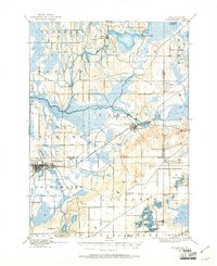
1903 Map of Whitewater
USGS Topo · Published 1961About this map
Whitewater serves as a primary hub in this early twentieth-century survey, situated where the Chicago rail line crosses a landscape defined by glacial moraines and extensive wetlands. To the northeast, the Scuppernong River and Bark River systems dictate the local settlement patterns, supporting small milling communities such as Heaths Mills and Rome. The region is a patchwork of early Wisconsin townships, including Lagrange and Sullivan, where agricultural clearings like Heart Prairie sit alongside the deep kettle lakes of the southeast. The intricate shoreline of the Lauderdale Lakes and Mill Lake indicates the area's early emergence as a recreational water destination. The presence of the Milwaukee and St. Paul railroad through Palmyra further illustrates how mid-century infrastructure shaped these Jefferson and Walworth County communities before the expansion of modern road networks.
Find a feature on this map
39 named features on this map. Tap any name to fly to it.
Don’t see what you’re looking for? This feature index may not catch every label — zoom into the map to look around manually.
Map Details
Editions of this 1903 Whitewater Map
5 editions found

Other maps of this area

1891 · Waterloo
USGS Topo · 1:62,500

1891 · Koshkonong
USGS Topo · 1:62,500

1892 · Watertown
USGS Topo · 1:62,500

1892 · Oconomowoc
USGS Topo · 1:62,500

1892 · Whitewater
USGS Topo · 1:62,500

1892 · Eagle
USGS Topo · 1:62,500

1893 · Delavan
USGS Topo · 1:62,500

1893 · Whitewater
USGS Topo · 1:62,500

1893 · Shopiere
USGS Topo · 1:62,500

1893 · Geneva
USGS Topo · 1:62,500