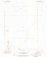
1954 Map of Wig Mtn SW
USGS Topo · Published 1986About this map
Dugway Proving Ground dominates the southern portion of this mid-century landscape, a terrain defined by its strategic military isolation in the Great Salt Lake Desert. The northern half of the survey is occupied by the Wendover Bombing and Gunnery Range, illustrating the vast scale of the Utah testing grounds during the Cold War era. The topographic data, compiled from 1953 aerial photography and 1954 plane-table methods, reveals a nearly level expanse with subtle elevation changes, marked only by ephemeral drainage patterns and isolated rocky outcrops. This map captures a strictly controlled military environment where the absence of civilian settlements or public roads underscores the area's specialized role in national defense and weapons testing.
Find a feature on this map
5 named features on this map. Tap any name to fly to it.
Don’t see what you’re looking for? This feature index may not catch every label — zoom into the map to look around manually.
Map Details
Editions of this 1954 Wig Mtn SW Map
4 editions found
Other maps of this area

1953 · Tooele
USGS Topo · 1:250,000

1954 · Wig Mtn SW
USGS Topo · 1:24,000

1954 · Dugway Proving Ground NE
USGS Topo · 1:24,000

1954 · Wildcat Mtn
USGS Topo · 1:24,000

1954 · Granite Peak
USGS Topo · 1:24,000

1954 · Wildcat Mtn SE
USGS Topo · 1:24,000

1954 · Dugway Proving Ground NW
USGS Topo · 1:24,000

1954 · Wig Mtn NW
USGS Topo · 1:24,000

1955 · Wig Mtn
USGS Topo · 1:24,000

1955 · Wig Mtn NE
USGS Topo · 1:24,000