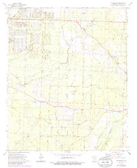
1973 Map of Woodberry
USGS Topo · Published 1986About this map
An Abandoned Ammunition Depot dominates the northwestern corner of this Calhoun County survey, its grid-like network of structures and bunkers contrasting with the winding drainages of Locust Bayou and Caney Creek. The map documents a landscape defined by small rural hubs and a network of named timber and service roads, including the East Camden and Tram Road and Highland Road. The community of Woodberry serves as the central point for local commerce, while rural spiritual life is represented by New Hope Ch, Faustina Ch, and Union Ch. Genealogical value is found in the Dunn Cem and several family-named landmarks like Silman Road and Covington Road. Scattered Gravel Pits indicate local industry tucked between the creek bottoms and rising timberland.
Find a feature on this map
29 named features on this map. Tap any name to fly to it.
Don’t see what you’re looking for? This feature index may not catch every label — zoom into the map to look around manually.
Map Details
Editions of this 1973 Woodberry Map
2 editions found
Other maps of this area

1903 · Camden
USGS Topo · 1:125,000

1934 · Moro Bay
USGS Topo · 1:62,500

1938 · Moro Bay
USGS Topo · 1:62,500

1939 · Moro Bay
USGS Topo · 1:62,500

1953 · El Dorado
USGS Topo · 1:250,000

1957 · El Dorado
USGS Topo · 1:250,000

1958 · El Dorado
USGS Topo · 1:250,000

1960 · El Dorado
USGS Topo · 1:250,000

1962 · Smackover NE
USGS Topo · 1:24,000

1962 · Snow Hill
USGS Topo · 1:24,000