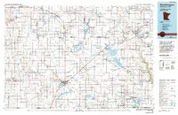
1985 Map of Worthington
USGS Topo · Published 1994About this map
Worthington and its landmark Okabena Lake anchor this 1985 survey of the prairie landscape along the Minnesota-Iowa border. The map reveals a highly structured agricultural grid, punctuated by numerous glacial lakes and extensive conservation areas like the Talcot Lake State Wildlife Management Area and Kilen Woods State Park along the Des Moines River. These public lands, often bordering water bodies like Heron Lake and South Heron Lake, suggest a late 20th-century landscape where drainage ditches and wildlife management co-exist. Strategic rail corridors and highways connect regional hubs such as Slayton, Jackson, and Windom, while smaller settlements like St Kilian, Kinbrae, and Wirock indicate the persistent legacy of the rural post-office and grain-elevator network. The presence of numerous Judicial Ditch labels highlights the intensive water management necessary for the region's productive farmland.
Find a feature on this map
149 named features on this map. Tap any name to fly to it.
Don’t see what you’re looking for? This feature index may not catch every label — zoom into the map to look around manually.
Map Details
Editions of this 1985 Worthington Map
2 editions found
Other maps of this area

1953 · Watertown
USGS Topo · 1:250,000

1953 · New Ulm
USGS Topo · 1:250,000

1954 · Fairmont
USGS Topo · 1:250,000

1955 · Sioux Falls
USGS Topo · 1:250,000

1957 · New Ulm
USGS Topo · 1:250,000

1958 · New Ulm
USGS Topo · 1:250,000

1958 · Sioux Falls
USGS Topo · 1:250,000

1958 · Fairmont
USGS Topo · 1:250,000

1958 · Watertown
USGS Topo · 1:250,000

1960 · Brewster
USGS Topo · 1:24,000