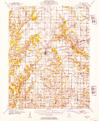
1952 Map of Xenia
USGS Topo · Published 1954About this map
The village of Xenia sits at the intersection of a developing energy landscape and traditional agriculture during the early 1950s. The Baltimore and Ohio railroad cuts a direct east-west path through the center of the sheet, anchoring settlements like Kenner and supporting the industrial output of the Xenia Oil Field and North Kenner Oil Field. Beyond the rail corridors, the terrain is defined by a dense network of rural infrastructure, including dozens of country schools such as Lincoln Sch and Oak Mound Sch, alongside local landmarks like the Christian Temple. To the south, the Skillet Fork river meanders through the landscape near Orchardville, while smaller hamlets like Johnsonville and Zenith mark the intersections of county roads. The map reveals a transition in rural education, specifically noting the Lone Star Sch (Abandoned), signaling the early stages of consolidation in these Southern Illinois communities.
Find a feature on this map
108 named features on this map. Tap any name to fly to it.
Don’t see what you’re looking for? This feature index may not catch every label — zoom into the map to look around manually.
Map Details
Editions of this 1952 Xenia Map
2 editions found

Other maps of this area

1933 · Mount Vernon
USGS Topo · 1:48,000

1934 · Salem
USGS Topo · 1:62,500

1938 · Salem
USGS Topo · 1:62,500

1940 · Mount Vernon
USGS Topo · 1:62,500

1945 · Kinmundy
USGS Topo · 1:62,500

1947 · Kinmundy
USGS Topo · 1:62,500

1947 · Wayne City
USGS Topo · 1:62,500

1948 · Fairfield
USGS Topo · 1:62,500

1948 · Flora
USGS Topo · 1:62,500

1949 · Flora
USGS Topo · 1:62,500