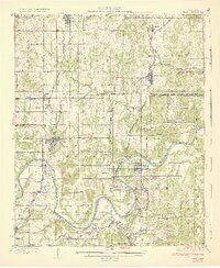
1932 Map of Yale
USGS Topo · Published 1932About this map
The Cimarron River winds through the heart of this North Central Oklahoma landscape, defining the industrial and social geography of the early 1930s. Centered on the town of Yale, the map reveals a region dense with rural infrastructure, including a proliferation of country schools such as Silver Creek Sch and Forest Home Sch. The era's oil and gas economy is clearly visible through the presence of clustered Oil Tanks near Oilton and Pemeta, while the intricate network of the Missouri Kansas Texas, St Louis San Francisco, and Atchison Topeka and Santa Fe railroads illustrates the vital transport links between settlements like Jennings and Maramec. The map also preserves the complex political history of the area, marking the Old Ind Ter Okla Bdy and the South Boundary Cherokee Outlet.
Find a feature on this map
57 named features on this map. Tap any name to fly to it.
Don’t see what you’re looking for? This feature index may not catch every label — zoom into the map to look around manually.
Map Details
Editions of this 1932 Yale Map
3 editions found

Other maps of this area

1901 · Nuyaka
USGS Topo · 1:125,000

1908 · Agra
USGS Topo · 1:62,500

1912 · Hominy
USGS Topo · 1:125,000

1915 · Hominy
USGS Topo · 1:125,000

1915 · Hominy
USGS Topo · 1:62,500

1916 · Bristow
USGS Topo · 1:62,500

1929 · Yale
USGS Topo · 1:62,500

1929 · Ripley
USGS Topo · 1:62,500

1929 · Skedee
USGS Topo · 1:62,500

1930 · Pawnee
USGS Topo · 1:62,500