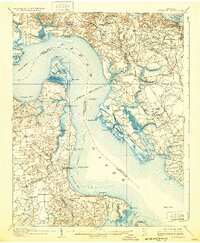
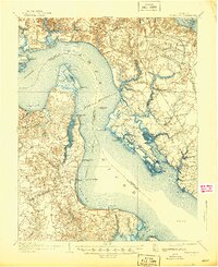
1907 Map of Yorktown
USGS Topo · Published 1932About this map
Yorktown and the surrounding Tidewater landscape appear here as they were surveyed in the early twentieth century, a region defined by its deep colonial roots and maritime commerce. The map documents the strategic peninsula between the James River and York River, punctuated by early military sites like Old Fort McPherson and the Colonial National Monument. A river-based economy is evident through numerous landings and wharves, including Fergussons Wharf and the Kingsmill Old Wharf, while the Chesapeake and Ohio railroad cuts across the landscape near Lee Hall. Notable inland features like the Warwick Courthouse and the Denbigh PO anchor the local community, while the ruins of Fort Crawford and Fort Boykin stand as silent witnesses to the area's long-standing defensive importance at the water's edge.
Find a feature on this map
88 named features on this map. Tap any name to fly to it.
Don’t see what you’re looking for? This feature index may not catch every label — zoom into the map to look around manually.
Map Details
Editions of this 1907 Yorktown Map
6 editions found
Other maps of this area

1906 · Williamsburg
USGS Topo · 1:62,500

1907 · Norfolk
USGS Topo · 1:125,000

1907 · Yorktown
USGS Topo · 1:62,500

1907 · Hampton
USGS Topo · 1:62,500

1916 · Mathews
USGS Topo · 1:62,500

1917 · Mathews
USGS Topo · 1:62,500

1917 · Toano
USGS Topo · 1:62,500

1918 · Toano
USGS Topo · 1:62,500

1919 · Smithfield
USGS Topo · 1:62,500

1919 · Surry
USGS Topo · 1:62,500