
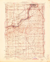
1925 Map of Yorkville
USGS Topo · Published 1925About this map
The Fox River valley serves as the central artery for this mid-1920s landscape, connecting the growing southern outskirts of Aurora to the county seat at Yorkville. This era reveals a sophisticated transportation network where traditional heavy rail like the Chicago Burlington and Quincy operates alongside interurban lines such as the Aurora Elgin and Chicago Electric and the Illinois Traction System. These electric railways provided vital links between small agricultural hubs like Oswego and Bristol.
Find a feature on this map
81 named features on this map. Tap any name to fly to it.
Don’t see what you’re looking for? This feature index may not catch every label — zoom into the map to look around manually.
Map Details
Editions of this 1925 Yorkville Map
2 editions found
Other maps of this area

1892 · Morris
USGS Topo · 1:62,500

1892 · Marseilles
USGS Topo · 1:62,500

1892 · Joliet
USGS Topo · 1:62,500

1892 · Wilmington
USGS Topo · 1:62,500

1908 · Wheaton
USGS Topo · 1:62,500

1916 · Marseilles
USGS Topo · 1:62,500

1918 · Wilmington
USGS Topo · 1:62,500

1918 · Morris
USGS Topo · 1:62,500

1923 · Joliet
USGS Topo · 1:62,500

1932 · Geneva
USGS Topo · 1:62,500