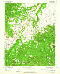
1953 Map of Youngsville
USGS Topo · Published 1964About this map
Youngsville and Coyote anchor this high-desert landscape in northern New Mexico during the early 1950s. The terrain is defined by the massive canyon-cut mesas of the Santa Fe National Forest and the historical expanse of the Piedra Lumbre Grant. Waterways like the Rio Puerco and Rito Encino carve deep through the plateau, creating a network of riparian corridors that historically dictated movement and settlement in the region.
Find a feature on this map
23 named features on this map. Tap any name to fly to it.
Don’t see what you’re looking for? This feature index may not catch every label — zoom into the map to look around manually.
Map Details
Editions of this 1953 Youngsville Map
3 editions found
Other maps of this area

1909 · Gallina
USGS Topo · 1:125,000

1918 · Abiquiu
USGS Topo · 1:125,000

1953 · Canones
USGS Topo · 1:24,000

1953 · Cerro Del Grant
USGS Topo · 1:24,000

1953 · Polvadera Peak
USGS Topo · 1:24,000

1953 · Echo Ampitheater
USGS Topo · 1:24,000

1953 · Arroyo Del Agua
USGS Topo · 1:24,000
1953 · Jarosa
USGS Topo · 1:24,000

1953 · Laguna Peak
USGS Topo · 1:24,000

1953 · Youngsville
USGS Topo · 1:24,000