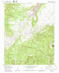
1953 Map of Youngsville
USGS Topo · Published 1980About this map
Piedra Lumbre Grant lands and the rugged northern reaches of the Santa Fe National Forest define this landscape as it was documented in the early 1950s. The settlement of Youngsville sits at the base of the foothills, where the Youngsville Cem and local road networks meet the Rio Puerco. To the southwest, the community of Coyote is situated near the Coyote Ranger Station, serving as a gateway to the high country. The map captures a transition from grazing grant lands to the forested peaks and canyons of the national forest, marked by landmarks such as Cerro Pedernal and Mesa Naranja. Small traces of individual residency and seasonal use appear in the backcountry, including the C. Serrano Cabin and F. Serrano Cabin, connected by a network of drainage systems like Coyote Creek and Rito de las Sillas.
Find a feature on this map
24 named features on this map. Tap any name to fly to it.
Don’t see what you’re looking for? This feature index may not catch every label — zoom into the map to look around manually.
Map Details
Editions of this 1953 Youngsville Map
3 editions found
Other maps of this area

1909 · Gallina
USGS Topo · 1:125,000

1918 · Abiquiu
USGS Topo · 1:125,000

1953 · Canones
USGS Topo · 1:24,000

1953 · Cerro Del Grant
USGS Topo · 1:24,000

1953 · Polvadera Peak
USGS Topo · 1:24,000

1953 · Echo Ampitheater
USGS Topo · 1:24,000

1953 · Arroyo Del Agua
USGS Topo · 1:24,000
1953 · Jarosa
USGS Topo · 1:24,000

1953 · Laguna Peak
USGS Topo · 1:24,000

1953 · Youngsville
USGS Topo · 1:24,000