1910s Maps of Alabama
Explore 11 historic maps of Alabama from the 1910s. These maps offer a rare glimpse into what life looked like during the 1910s — showing old roads, neighborhoods, homes, and landmarks that have changed or disappeared over time.
Whether you're researching your family's past, planning a metal detecting trip, or studying how Alabama's landscape evolved across the 1910s, these high-resolution maps are a powerful tool for exploring the history of this region.
- Focus on a specific era: All maps on this page are from the 1910s, giving you a focused view of this time period.
- See what’s changed: Compare century-old streets, trails, and buildings to today's modern landscape using overlays and satellite layers.
- Research with precision: Use these maps for genealogy, historical research, land use analysis, or educational projects.
- View, download, or print: Maps are fully viewable online in high resolution, and can be downloaded or printed for your own records.
Start exploring Alabama's history through authentic maps from the 1910s. This is your window into the past.
Alabama maps
(11)- 1910 Map of Montevallo
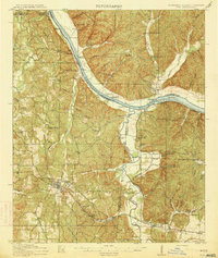
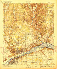
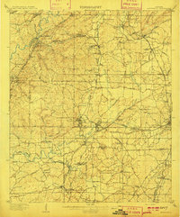 1910 Montevallo1910 Print · USGSCentral Alabama’s coal and iron corridor is captured here at a peak of industrial expansion. Researchers can trace the heritage of vanished mining camps and family landmarks from Boothon to the Bibb Furnace (RUINS) and Sessions Chapel.4 unique versions available
 - 1911 Map of Columbiana
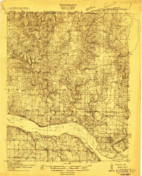
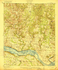
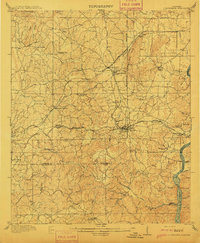 1911 Columbiana1911 Print · USGSCentral Alabama's industrial landscape is captured here just after the first decade of the century, showing a region deeply connected by rail and river. Genealogists can trace family names at Woods Ferry or locate old community hubs like Summer Hill School and Kingdom Church.2 unique versions available
 - 1911 Map of Iuka
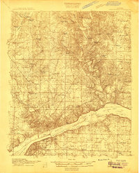
 1911 Iuka1911 Print · USGSThe tri-state border region of Mississippi, Alabama, and Tennessee is captured here at the peak of the river-landing era. Genealogists can trace family connections through numerous river access points like Shellbank Landing and rural landmarks such as Salem Church and Jackson Ridge School.2 unique versions available
 - 1914 Map of Seale
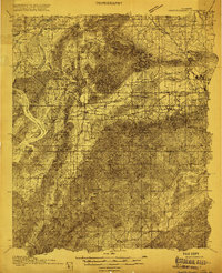
 1914 Seale1914 Print · USGSRussell County's agricultural and railroad landscape is meticulously documented just before the First World War. Genealogists can trace family connections through local landmarks like Kite School, the community of Sand Fort, and historical river crossings like Perrys Ford.6 unique versions available
 - 1914 Map of Iuka
 1914 Iuka1914 Print · USGSThe Tennessee River valley at the Mississippi and Alabama border was a busy network of landings and rail junctions in the early twentieth century. Researchers can trace riverfront life at Eastport Landing or locate rural family landmarks like Salem Church and Guthrie School.4 unique versions available
 - 1914 Map of Rogersville
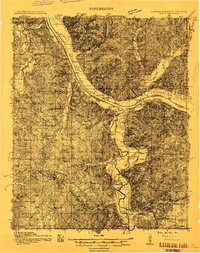
 1914 Rogersville1914 Print · USGSBefore the Tennessee River was dammed and widened, this area supported a dense network of river-linked communities. Trace the legacy of early families through landmarks like Lambs Ferry, Mitchell Mill, and the many rural sites like Sweet Gum Church.
 - 1914 Map of Muscle Shoals
 1914 Muscle Shoals1914 Print · USGSThe Tennessee River and its complex shoals define the Shoals region in the years before major damming projects. Trace the Muscle Shoals Canal and find landmarks like St Florian, Mars Hill School, and Lock No 6.
 - 1915 Map of Gantts Quarry
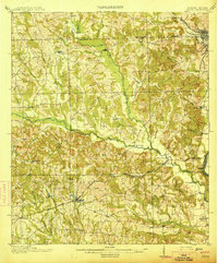
 1915 Gantts Quarry1915 Print · USGSTalladega and Shelby counties appear here during the height of the early twentieth-century marble boom. Researchers can trace the rail-driven economy near Sylacauga and locate family landmarks like Oak Grove Church, Gantts Quarry, and Center Hill School.4 unique versions available
 - 1916 Map of Muscle Shoals
 1916 Muscle Shoals1916 Print · USGSThe Tennessee River corridor around Florence and Sheffield appears here in the years before dam construction altered the valley forever. Researchers can trace historic river crossings like Goose Shoals Ford, early navigation locks, and vanished community hubs such as Big Cut Hines PO.2 unique versions available
 - 1916 Map of Rogersville
 1916 Rogersville1916 Print · USGSLauderdale County was a landscape of river-driven commerce and rural crossroads in the decade before the Tennessee River was transformed. Researchers can trace ancestral locations through dozens of named sites like Lambs Ferry, Hurricane Church, and the Muscle Shoals Canal.2 unique versions available
 - 1917 Map of Gantts Quarry
 1917 Gantts Quarry1917 Print · USGSThe marble-rich corridor between the Coosa River and Sylacauga is captured here during the height of the early twentieth-century quarrying boom. Researchers can trace the rail-and-river economy through landmarks like Gantts Quarry, Mc Gowan Ferry, and Eureka Quarry.3 unique versions available
End of results
Showing maps 1-11 of 11
Top cities of Alabama
- Huntsville historical maps
- Birmingham historical maps
- Montgomery historical maps
- Mobile historical maps
- Tuscaloosa historical maps
- Hoover historical maps
See more
Top counties of Alabama
- Jefferson County historical maps
- Mobile County historical maps
- Madison County historical maps
- Baldwin County historical maps
- Montgomery County historical maps
- Tuscaloosa County historical maps
See more
Frequently asked questions
- What are the different types of historical maps available for Alabama?
- What is the oldest map of Alabama?
- Where can I purchase historical maps of Alabama for my home or office?
- Where can I download high-res historical maps of Alabama?
- Are there historical topographic maps available for Alabama?
- Is there historical aerial imagery available for Alabama?
- Where are historical maps of Alabama sourced from?