Old Maps of Alabama for Academic Research
Study the evolution of Alabama with 2,705 high-resolution historic maps. Whether you're teaching, researching, or modeling changes in land use, these maps provide essential visual documentation of urban, environmental, and geographic change.
- Analyze long-term change: Track patterns in development, transportation, and natural features.
- Ideal for environmental or urban studies: Support academic projects with primary historical map data.
- Use in the classroom or lab: Educators and researchers rely on these maps to bring historical context to life.
These maps are a powerful tool for teaching, research, and visualizing how Alabama has changed over the decades.
Alabama maps
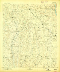
(2,705)- 1885 Map of Gadsden
 1885 Gadsden1885 Print · USGSNortheast Alabama in the mid-1880s was a landscape of river-side landings and emerging rail towns. Genealogists and historians can trace the early foundations of Guntersville and Gadsden while locating rural landmarks like Hillian Store, Cottonville, and Law Landing.
 - 1886 Map of Rome
 1886 Rome1886 Print · USGSNorthwest Georgia in the mid-1880s is captured as a vital junction of river navigation and emerging rail power. Genealogists and historians can trace family locations near Rome and Cedartown or find rural landmarks like Kirk's Grave and Cunningham or Agate P.O.
 - 1886 Map of Stevenson
 1886 Stevenson1886 Print · USGSNortheast Alabama at the peak of the railroad era shows a landscape tied to the river and the rails. Genealogists can trace family landmarks like Coffey's Store or locate river crossings such as Caperton Ferry and Snodgrass Ferry.
 - 1888 Map of Cullman
 1888 Cullman1888 Print · USGSCullman and Morgan counties are shown in the late 1880s as the railroad fueled growth across the Sand Mountain region. Genealogists can trace early homesteads and commerce at Sobotka's Mill, Fort Bluff, and the riverside town of Blountsville.
 - 1888 Map of Gadsden
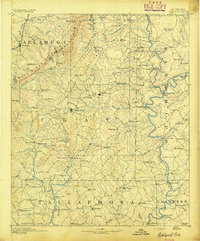
 1888 Gadsden1888 Print · USGSNorth Alabama's river valleys and plateau lands are captured here in the late nineteenth century as the region transitioned from river landings to rail transport. Researchers can locate early post offices and commerce centers like Hillian's Store, Guntersville, and the ferry at Ft Deposit.
 - 1888 Map of Scottsboro
 1888 Scottsboro1888 Print · USGSNortheast Alabama is shown in the late nineteenth century as a land of steep plateaus and vital river crossings. Genealogists and researchers can trace the early rail-and-river economy through family landmarks like Caldwell's Ferry and the Bell Factory textile site.
 - 1888 Map of Huntsville
 1888 Huntsville1888 Print · USGSMadison and Limestone counties in the late 1880s showcase a landscape defined by the Tennessee River and major early rail lines. Researchers can trace the layout of Huntsville or locate long-standing communities like Mooresville and Thompsons Mill.
 - 1889 Map of Tallapoosa
 1889 Tallapoosa1889 Print · USGSAcross the Georgia and Alabama border in the late nineteenth century, iron furnaces and river mills powered the local economy. Genealogists can trace family homesteads near landmarks like Tecumseh Furnace, Pine Wood Church, and Allgood's Mill.
 - 1889 Map of Springville
 1889 Springville1889 Print · USGSSt. Clair County and its neighbors are mapped here during the late Victorian era as railroads began to transform the old plantation and river economy. Genealogists can locate family landmarks like Henry's Mill, trace the path of Jackson's Trace, or find the location of old river crossings at Colman's Ferry.
 - 1889 Map of Birmingham
 1889 Birmingham1889 Print · USGSIn the late nineteenth century, the Iron City was a growing urban core surrounded by intensive extraction sites and river crossings. Trace early industrial footprints at the Pratt Mines, Sloss Quarry, and the Old Irondale Furnace.
 - 1890 Map of Bessemer
 1890 Bessemer1890 Print · USGSCentral Alabama emerges as an industrial powerhouse in the late nineteenth century as railroads weave through the ridges of Jefferson and Shelby counties. Genealogists and historians can trace the early footprints of Bessemer, the iron operations at Sloss, and remote landmarks like Woods Ferry.
 - 1890 Map of Talladega
 1890 Talladega1890 Print · USGSTalladega and the surrounding river valleys are captured here in the late nineteenth century as the railroad and river economy flourished. Trace the locations of historic river crossings like Old Kymulga Ferry and local landmarks such as Odens Mill.
 - 1891 Map of Clanton
 1891 Clanton1891 Print · USGSChilton and Autauga counties are shown here in the 1890s, when the river-and-rail economy defined Central Alabama. Genealogists and historians can trace the foundations of Clanton and rural landmarks like Big Spring Church, Adam's Ferry, and Ousley Store.5 unique versions available
 - 1891 Map of Ashland
 1891 Ashland1891 Print · USGSEast Central Alabama in the late nineteenth century is defined by the sharp ridges of the mountains and the vital crossings of the Tallapoosa River. Genealogists can trace family movements across Malone's Ferry or locate vanished sites like the Pine Tuckey Town Site and Ironaton.5 unique versions available
 - 1892 Map of Cullman
 1892 Cullman1892 Print · USGSNorth-central Alabama's development is centered on the railroad corridor and rugged plateau country in the late nineteenth century. Genealogists can trace family footprints at Sobotka's Mill, along the historic Stout's Road, or near the remote Newsome Sinks.4 unique versions available
 - 1892 Map of Birmingham
 1892 Birmingham1892 Print · USGSBirmingham and the surrounding iron district emerge in the late nineteenth century as a hub of heavy industry and rail expansion. Trace the early footprints of the Sloss Mine, locate river crossings like Doss Ferry, and find family-named landmarks like Hanby Mill.
 - 1892 Map of Springville
 1892 Springville1892 Print · USGSNortheast Alabama at the end of the nineteenth century is a landscape of river crossings and expanding rail lines. Genealogists can trace family footprints at St. Clair Springs, Greensport, and numerous river crossings like Colman's Ferry or Goodwin's Mill.7 unique versions available
 - 1892 Map of Huntsville
 1892 Huntsville1892 Print · USGSNorth Alabama was a landscape of river ferries and rising rail hubs in the 1890s, caught here just as the region's industry began to modernize. Researchers can locate vanished landmarks like the Monte Sano Hotel and trace old family-named sites from Thompsons Mill to Lemans Ferry.6 unique versions available
 - 1892 Map of Scottsboro
 1892 Scottsboro1892 Print · USGSJackson County and the Tennessee River valley are captured here in the late nineteenth century, just as railroads began to reshape local commerce. Genealogists can trace family-named sites like Owen's Cross Roads, Carrick Mill, and Larkin Landing.5 unique versions available
 - 1892 Map of Talladega
 1892 Talladega1892 Print · USGSTalladega County and the Coosa River valley are captured here in the late nineteenth century as the regional rail network expanded through the mountains. Researchers can locate old river crossings like Chancelors Ferry, rural landmarks such as Edwards Store, and early hubs like Childersburgh.6 unique versions available
 - 1892 Map of Stevenson
 1892 Stevenson1892 Print · USGSNortheast Alabama and the Tennessee border in the 1890s reveal a landscape of mountain coves and vital river crossings. Genealogists and historians can trace rail junctions at Stevenson, river landings like Coffey's Ferry, and landmarks like Nickajack Cave.
 - 1892 Map of Tallapoosa
 1892 Tallapoosa1892 Print · USGSThe Georgia-Alabama borderlands at the end of the nineteenth century reveal a landscape of early industry and river-powered mills. Genealogists and historians can trace family-named landmarks like Allgood Mill, Rainwater Ford, and the Tecumseh Furnace ruins.
 - 1892 Map of Gadsden
 1892 Gadsden1892 Print · USGSNorth Alabama's river-and-rail economy is captured here in the late nineteenth century as Guntersville and Gadsden emerge as regional hubs. Genealogists and historians can trace the routes of the Birmingham Mineral R. R. or locate old community centers like Cottonville and Mt Zion.
 - 1892 Map of Bessemer
 1892 Bessemer1892 Print · USGSCentral Alabama was at its industrial peak in the late nineteenth century as railroads and iron mines transformed the ridges south of Birmingham. Genealogists and researchers can trace the early foundations of Bessemer, the operations at Smith Mine, and rural crossings like Nunley's Ford.2 unique versions available
 - 1893 Map of Jasper
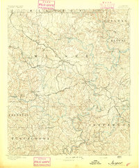 1893 Jasper1893 Print · USGSNorthern Alabama’s coal and timber country comes into focus in the 1890s as railroads began to penetrate the river valleys. Genealogists and historians can trace family-named river crossings like Miller Ferry and Baltimore Ford or early industry at Gamble Mines.5 unique versions available
Showing maps 1-25 of 2,705
Top cities of Alabama
- Huntsville historical maps
- Birmingham historical maps
- Montgomery historical maps
- Mobile historical maps
- Tuscaloosa historical maps
- Hoover historical maps
See more
Top counties of Alabama
- Jefferson County historical maps
- Mobile County historical maps
- Madison County historical maps
- Baldwin County historical maps
- Montgomery County historical maps
- Tuscaloosa County historical maps
See more
Frequently asked questions
- What are the different types of historical maps available for Alabama?
- What is the oldest map of Alabama?
- Where can I purchase historical maps of Alabama for my home or office?
- Where can I download high-res historical maps of Alabama?
- Are there historical topographic maps available for Alabama?
- Is there historical aerial imagery available for Alabama?
- Where are historical maps of Alabama sourced from?