1950s Maps of Wrangell, Alaska
Explore 36 historic maps of Wrangell from the 1950s. These maps offer a rare glimpse into what life looked like during the 1950s — showing old roads, neighborhoods, homes, and landmarks that have changed or disappeared over time.
Whether you're researching your family's past, planning a metal detecting trip, or studying how Wrangell's landscape evolved across the 1950s, these high-resolution maps are a powerful tool for exploring the history of this region.
- Focus on a specific era: All maps on this page are from the 1950s, giving you a focused view of this time period.
- See what’s changed: Compare century-old streets, trails, and buildings to today's modern landscape using overlays and satellite layers.
- Research with precision: Use these maps for genealogy, historical research, land use analysis, or educational projects.
- View, download, or print: Maps are fully viewable online in high resolution, and can be downloaded or printed for your own records.
Start exploring Wrangell's history through authentic maps from the 1950s. This is your window into the past.
Wrangell, AK maps
(36)- 1950 Map of Craig D-3, 1953 Print
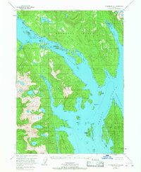
 1950 Craig D-31953 Print · USGSSoutheast Alaska in the mid-twentieth century is captured here as a maritime and mountain wilderness. Researchers can trace the original shorelines and interior basins including Sweetwater Lake, Coffman Cove, and the winding Thorne River.2 unique versions available
 - 1950 Map of Craig C-1, 1966 Print
 1950 Craig C-11966 Print · USGSThe rugged coastlines of the Cleveland Peninsula and Prince of Wales Island are captured here in the mid-century era. Historians can trace the legacy of local mining at Sleeping Beauty Mine and locate the site of the former settlement at Hadley.4 unique versions available
 - 1951 Map of Craig D-2, 1952 Print
 1951 Craig D-21952 Print · USGSPrince of Wales and Etolin Islands are captured in the early fifties, showing the maritime geography of the Alexander Archipelago. Maritime researchers can trace protected waters like McHenry Anchorage, Ratz Harbor, and Dewey Anchorage.2 unique versions available
 - 1951 Map of Bradfield Canal, 1953 Print
 1951 Bradfield Canal1953 Print · USGSSoutheast Alaska in the early fifties reveals a landscape of massive glaciers and remote waterways along the Canadian border. Researchers can locate early industrial sites like the Riverside Mine and coastal landmarks such as Anan Lagoon or the Government Cabin.3 unique versions available
 - 1951 Map of Craig C-1, 1953 Print
 1951 Craig C-11953 Print · USGSThe Cleveland Peninsula and Prince of Wales Island are shown in the early fifties, documenting a landscape of maritime outposts and dormant mining camps. Genealogists and researchers can trace the abandoned site of Hadley and several inactive operations like the Mamie Mine or Sleeping Beauty Mine.2 unique versions available
 - 1951 Map of Craig D-1, 1953 Print
 1951 Craig D-11953 Print · USGSSoutheast Alaska’s intricate coastline is charted here in the early fifties, detailing the deep waters and islands of the Alexander Archipelago. Researchers can locate remote coastal sites like Cannery (Aband) and family-named landmarks like Petersen Is and Mt Burnett.2 unique versions available
 - 1951 Map of Petersburg B-4, 1954 Print
 1951 Petersburg B-41954 Print · USGSSoutheast Alaska’s maritime corridors are documented here in the early fifties, focusing on the junction of Sumner Strait and Clarence Strait. Researchers can trace old navigation aids like The Eye Opener Light and explore coastal features from Red Bay to the Bushy Islands.2 unique versions available
 - 1951 Map of Petersburg B-3, 1954 Print
 1951 Petersburg B-31954 Print · USGSZarembo Island and the surrounding waterways of Southeast Alaska appear here in the early fifties. Maritime researchers and historians can trace the intricate shoreline from St John Harbor to Meter Bight and identify landmarks like Pt Howe and Station Island.2 unique versions available
 - 1951 Map of Petersburg C-2, 1965 Print
 1951 Petersburg C-21965 Print · USGSSoutheastern Alaska's coastal islands and glacial waterways are captured here at mid-century, just as aerial photography began to detail the complex Stikine Delta. Researchers can trace remote outposts like Camp I, mineral sites at Garnet Ledge, and the early Highway route on Mitkof Island.2 unique versions available
 - 1951 Map of Petersburg A-1, 1968 Print
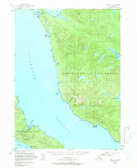
 1951 Petersburg A-11968 Print · USGSWrangell and Etolin Islands are captured here in the early fifties, showing a landscape defined by maritime access and isolated settlements. Researchers can trace the layout of the Village Islands, the small settlement of Village, and remote encampments at Thoms Place.2 unique versions available
 - 1952 Map of Petersburg, 1953 Print
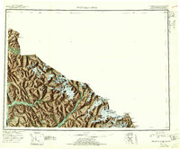
 1952 Petersburg1953 Print · USGSSoutheast Alaska's intricate Alexander Archipelago comes to life in the early fifties, documenting a landscape of remote island settlements and maritime corridors. Genealogists and historians can trace coastal life in Petersburg and Wrangell, or locate early industry at Shakan and regional Mines.5 unique versions available
 - 1952 Map of Ketchikan, 1953 Print
 1952 Ketchikan1953 Print · USGSThe Ketchikan region of Southeast Alaska is mapped here in the early fifties, documenting the remote settlements and deep-water inlets of the southern panhandle. Genealogists and historians can trace the foundations of Ketchikan, Metlakatla, and Saxman alongside lonely backcountry cabins.4 unique versions available
 - 1952 Map of Ketchikan C-6, 1954 Print
 1952 Ketchikan C-61954 Print · USGSCoastal Southeast Alaska in the early fifties shows a wilderness of islands and waterways shaped by the gold mining industry. Researchers can trace the locations of the Gold Standard Mine (Inactive), the Alaska-Gold Mtn Mines, and isolated structures like the Cabin at Helm Bay.2 unique versions available
 - 1952 Map of Ketchikan D-6, 1964 Print
 1952 Ketchikan D-61964 Print · USGSThe Ketchikan region in the early fifties reveals a remote maritime landscape of deep inlets and isolated coastal stations. Genealogists and historians can locate the Fish Hatchery (Aband) at Yes Bay and the Lighthouse Reserve along the Behm Canal.3 unique versions available
 - 1953 Map of Petersburg A-4, 1954 Print
 1953 Petersburg A-41954 Print · USGSSoutheast Alaska's intricate Alexander Archipelago is captured here in the early fifties, showing the water-dependent landscape of the Tongass National Forest. Researchers can trace the coastal site of Camp Taylor (Aband) or locate landmarks like El Capitan Peak and Neck Lake.2 unique versions available
 - 1953 Map of Petersburg A-3, 1954 Print
 1953 Petersburg A-31954 Print · USGSSoutheast Alaska's maritime frontier is detailed in this mid-century survey of the waters between Etolin Island and Prince of Wales Island. Researchers can locate industrial sites like the Cannery at Lake Bay or trace the coastline of Zarembo Island.2 unique versions available
 - 1953 Map of Ketchikan D-6, 1955 Print
 1953 Ketchikan D-61955 Print · USGSSoutheast Alaska's maritime landscape is captured here in the mid-fifties, showing the rugged coastline of the Cleveland Peninsula. Historians can trace early regional footprints at the Fish Hatchery (Aban'd) and the Lighthouse Reserve near Yes Bay.
 - 1953 Map of Petersburg C-1, 1964 Print
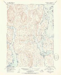
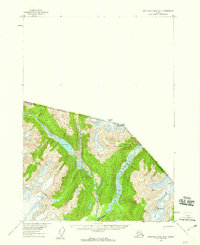
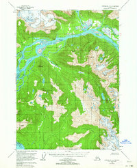 1953 Petersburg C-11964 Print · USGSThe Stikine River delta was a intricate maze of glacial runoff and tidal sloughs in the early fifties. Researchers can trace the braided channels around Andrew Island, locate the historic Chief Shakes Hot Springs, and identify peaks like Wrangell Peak.3 unique versions available
 - 1953 Map of Petersburg A-2, 1964 Print
 1953 Petersburg A-21964 Print · USGSEtolin Island in the early 1950s reveals a maritime landscape of deep fjords and peaks within the Tongass National Forest. Researchers can locate coastal industry at Cannery Pt and trace inland features like Hatchery Lake and Alice Peak.3 unique versions available
 - 1953 Map of Petersburg B-2, 1964 Print
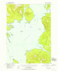
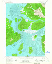
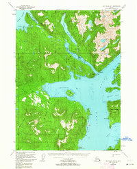
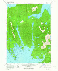
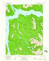
 1953 Petersburg B-21964 Print · USGSSoutheast Alaska’s maritime character is on full display in the mid-fifties, centered on the strategic hub of Wrangell. Genealogists and historians can trace the local infrastructure of the era, from the Wrangell Institute and Cem to the Seaplane Base and Logging Camp.3 unique versions available
 - 1953 Map of Petersburg C-3, 1964 Print
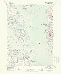
 1953 Petersburg C-31964 Print · USGSMitkof Island and the Wrangell Narrows are shown here during the early 1950s as maritime industry and island infrastructure expanded. Researchers can locate specialized sites like the Alaska Experimental Fur Farm, Papkes Landing, and the original route of the Mitkof Highway.2 unique versions available
 - 1954 Map of Bradfield Canal
 1954 Bradfield Canal1954 Print · USGSSoutheast Alaska's glacial fjords and high peaks are captured here in the mid-1950s, showing the intersection of the maritime economy and the deep wilderness. Researchers can trace early infrastructure like the Riverside Mine, the Cannery, and the Government Cabin.
 - 1955 Map of Bradfield canal A-6, 1959 Print
 1955 Bradfield canal A-61959 Print · USGSSoutheast Alaska's intricate waterways and forested islands are captured here in the mid-fifties, showing the region before modern development. Researchers can locate the isolated Cabin at Anan Lagoon and trace the drainage of Anan Lake into Anan Bay.3 unique versions available
 - 1955 Map of Bradfield canal B-3, 1959 Print
 1955 Bradfield canal B-31959 Print · USGSSoutheast Alaska and the Canadian borderland are captured in the mid-1950s when the wilderness was mapped primarily by aerial photography. Researchers can trace the glaciated peaks of Mt Stoeckl and the remote Cable Car crossing over the Blue River.3 unique versions available
 - 1955 Map of Bradfield canal A-4, 1959 Print
 1955 Bradfield canal A-41959 Print · USGSSoutheastern Alaska’s coastal wilderness comes into focus in the mid-1950s, centered on the convergence of major glacial rivers at the head of the tidewater. Researchers can locate remote homesteads like Bishop Ranch, tracing the braided channels of the Unuk River and the shores of Burroughs Bay.2 unique versions available
Showing maps 1-25 of 36
Top cities of Wrangell
Frequently asked questions
- What are the different types of historical maps available for Wrangell?
- What is the oldest map of Wrangell?
- Where can I purchase historical maps of Wrangell for my home or office?
- Where can I download high-res historical maps of Wrangell?
- Are there historical topographic maps available for Wrangell?
- Is there historical aerial imagery available for Wrangell?
- Where are historical maps of Wrangell sourced from?