1990s Maps of Wrangell, Alaska
Explore 20 historic maps of Wrangell from the 1990s. These maps offer a rare glimpse into what life looked like during the 1990s — showing old roads, neighborhoods, homes, and landmarks that have changed or disappeared over time.
Whether you're researching your family's past, planning a metal detecting trip, or studying how Wrangell's landscape evolved across the 1990s, these high-resolution maps are a powerful tool for exploring the history of this region.
- Focus on a specific era: All maps on this page are from the 1990s, giving you a focused view of this time period.
- See what’s changed: Compare century-old streets, trails, and buildings to today's modern landscape using overlays and satellite layers.
- Research with precision: Use these maps for genealogy, historical research, land use analysis, or educational projects.
- View, download, or print: Maps are fully viewable online in high resolution, and can be downloaded or printed for your own records.
Start exploring Wrangell's history through authentic maps from the 1990s. This is your window into the past.
Wrangell, AK maps
(20)- 1992 Map of Petersburg B-2 SE
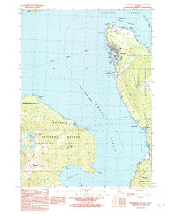
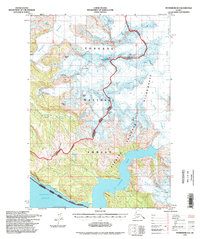
 1992 Petersburg B-2 SE1992 Print · USGSCoastal Wrangell and Etolin Island are seen here during the early nineties as the local road network expanded. Trace the path of the Zimovia Highway past Pats Lake or locate the remote waters of Kunk Lake and the prominent Nemo Point.
 - 1992 Map of Petersburg B-2 NE
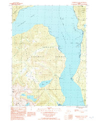
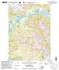
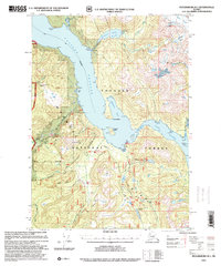
 1992 Petersburg B-2 NE1992 Print · USGSThe coastal community of Wrangell and its island neighbors are shown here in the early 1980s as the town serves its role as a maritime hub. You can trace local landmarks like Chief Shakes I, locate the Wrangell Institute, and find cultural sites such as the Petroglyphs.
 - 1992 Map of Petersburg C-3 SE
 1992 Petersburg C-3 SE1992 Print · USGSMitkof Island in the early nineties is a portrait of Southeast Alaskan wilderness and infrastructure along the Blind Slough. Researchers can trace the path of the Mitkof Highway to local landmarks like the Crystal Lake Fish Hatchery and Ohmer Creek Campground.
 - 1992 Map of Petersburg B-1 NW
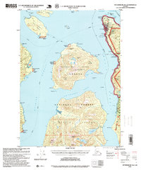
 1992 Petersburg B-1 NW1992 Print · USGSSoutheast Alaska’s intricate coastline is captured in the early nineties, centered on the waterway of Eastern Passage. Researchers can trace the rugged shoreline of Wrangell Island and locate landmarks like Virginia Lake and Babbler Point.
 - 1992 Map of Petersburg C-2 SW
 1992 Petersburg C-2 SW1992 Print · USGSSoutheast Alaska's coastal wilderness comes to life in this early 1990s survey of the intricate islands and straits near Wrangell. Genealogists and historians can trace local landmarks like the Ernie Haugen Public Use Area, the Mitkof Highway, and numerous islands including Rynda Island.
 - 1994 Map of Craig D-3, 1998 Print
 1994 Craig D-31998 Print · USGSPrince of Wales Island in the 1990s reflects a balance of wild terrain and forest management infrastructure. Researchers can trace the Honker Divide Canoe Portage and locate backcountry outposts like the Sweetwater Lake Cabin (FS).
 - 1994 Map of Petersburg D-2, 1998 Print
 1994 Petersburg D-21998 Print · USGSSoutheast Alaska in the mid-nineties shows a landscape of massive ice fields and tidal fjords within the Tongass National Forest. Researchers can trace the glacial flow of Le Conte Glacier and locate remote shoreline cabins along the edges of Le Conte Bay.
 - 1994 Map of Petersburg A-4, 1998 Print
 1994 Petersburg A-41998 Print · USGSPrince of Wales Island and the Tongass National Forest are shown in the 1990s as the timber industry and wilderness management shaped the coast. Researchers can trace land use near Whale Pass, El Capitan Work Center, and Camp Taylor (Site).
 - 1994 Map of Petersburg A-3, 1998 Print
 1994 Petersburg A-31998 Print · USGSCoastal life in Southeast Alaska's wilderness comes into focus during the 1990s as the timber and fishing industries left their mark on the archipelago. Researchers can locate remote Forest Service outposts like the Barnes Lake Cabin and industrial remains such as the Cannery Ruins and Log Transfer Facility.
 - 1994 Map of Craig D-2, 1998 Print
 1994 Craig D-21998 Print · USGSThe maritime landscape of Southeast Alaska is documented here in the mid-1990s as it spans the waters between Prince of Wales Island and Etolin Island. Researchers can trace old coastal sites like the Lighthouse Reserve, Cabin Ruins, and established anchorages at Ratz Harbor.
 - 1995 Map of Petersburg A-1, 1999 Print
 1995 Petersburg A-11999 Print · USGSSoutheast Alaska’s intricate coastline comes alive in this mid-nineties survey of the islands south of Wrangell. Local historians can trace maritime sites like the Abandoned Village, find the Thoms Lake Trail, and locate remote outposts such as Zimovia Cabin (State).
 - 1995 Map of Petersburg B-4, 1999 Print
 1995 Petersburg B-41999 Print · USGSSoutheast Alaska's intricate coastline is mapped during the mid-nineties as a network of maritime passages and timber management zones. Trace remote forest service outposts like the Salmon Bay Lake Cabin (FS) and coastal markers at Point Colpoys.
 - 1995 Map of Petersburg A-2, 1999 Print
 1995 Petersburg A-21999 Print · USGSEtolin Island in the mid-1990s shows a landscape of timber industry and marine transit within the Tongass National Forest. Trace the locations of the Logging Camp, the Oyster Farm, and old Ruins at Cannery Point.
 - 1995 Map of Petersburg B-3, 1999 Print
 1995 Petersburg B-31999 Print · USGSZarembo Island and its surrounding straits appear in the mid-nineties as a hub of maritime navigation and forestry work. Researchers can trace the era's coastal infrastructure through the Log Transfer Facility, the Lighthouse Reserve, and the Alaska Marine Highway.
 - 1995 Map of Bradfield Canal A-4, 1999 Print
 1995 Bradfield Canal A-41999 Print · USGSCoastal Alaska in the mid-nineties shows a landscape of deep fjords and river valleys where the Tongass National Forest meets the sea. Researchers can trace isolated outposts like Bishop Ranch and Matney Ranch along the banks of the Unuk River.
 - 1995 Map of Petersburg C-1, 1999 Print
 1995 Petersburg C-11999 Print · USGSThe Stikine River delta comes alive in this mid-nineties survey of the Alaskan wilderness. Researchers can trace remote Forest Service outposts like the Mount Rynda Cabin and geothermal landmarks including Chief Shakes Hot Springs.
 - 1995 Map of Ketchikan C-6, 1999 Print
 1995 Ketchikan C-61999 Print · USGSSoutheast Alaska’s maritime wilderness comes into focus in the mid-nineties, showing a landscape shaped by mining history and forest management. Researchers can trace early industrial footprints at the Gold Standard Mine or locate remote sites like Indian Graves and the Helm Bay Cabin (FS).
 - 1995 Map of Petersburg B-2, 1999 Print
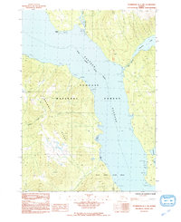
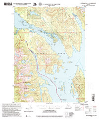
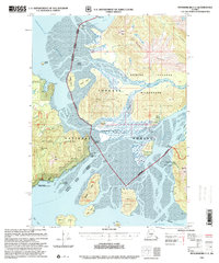
 1995 Petersburg B-21999 Print · USGSWrangell and the surrounding islands of the Tongass National Forest are captured here in the mid-nineties. Local researchers can locate family landmarks such as Dewey Hill, Cemetery Point, or the Church Camp on Vank Island.
 - 1997 Map of Petersburg B-1, 2000 Print
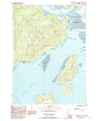
 1997 Petersburg B-12000 Print · USGSWrangell Island and the coastal inlets of Southeast Alaska are captured here at the end of the century. Trace historic sites and wilderness outposts like the Sawmill Ruins, Virginia Lake Cabin (FS), and the Salamander Ridge Trail.
 - 1997 Map of Petersburg C-2, 2000 Print
 1997 Petersburg C-22000 Print · USGSNear Wrangell in the late nineties, the Stikine River delta reveals a rugged landscape of wilderness cabins and silty flats. Researchers can locate remote outposts like Garnet Ledge Cabin (FS) or trace the path of the Ideal Cove Trail along the shoreline.
End of results
Showing maps 1-20 of 20
Top cities of Wrangell
Frequently asked questions
- What are the different types of historical maps available for Wrangell?
- What is the oldest map of Wrangell?
- Where can I purchase historical maps of Wrangell for my home or office?
- Where can I download high-res historical maps of Wrangell?
- Are there historical topographic maps available for Wrangell?
- Is there historical aerial imagery available for Wrangell?
- Where are historical maps of Wrangell sourced from?